
Make a donation
Chicxulub crater topographic map
Click on the map to display elevation.
Make a donation
About this map
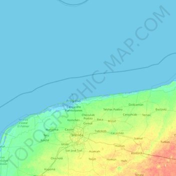
Name: Chicxulub crater topographic map, elevation, terrain.
Location: Chicxulub crater, Mexico (20.58387 -90.39090 22.21155 -88.64265)
Average elevation: 4 m
Minimum elevation: -4 m
Maximum elevation: 31 m
Make a donation
Other topographic maps
Click on a map to view its topography, its elevation and its terrain.
Jalisco
Jalisco is made up of a diverse terrain that includes forests, beaches, plains, and lakes. Altitudes in the state vary from 0 to 4,300 meters (0 to 14,110 ft) above sea level, from the coast to the top of the Nevado de Colima. The Jalisco area contains all five of Mexico's natural ecosystems: arid and semi…
Average elevation: 1,301 m
Río Balsas
The Balsas River has a discharge of 15–17 m3/s during the lean flow season. The steep slope of the river in a stretch of 30 km creates an elevation difference of 1200 m, providing excellent opportunities for hydropower development. Initially, 120 MW of power was generated at the power station at La Villita.…
Average elevation: 1,453 m
Make a donation
Arandas
Arandas is situated on the Mesa Central at an elevation of 6,762 feet (2,061 metres). Arandas is commonly known among Mexicans as the commercial and manufacturing centre for agricultural products (typically beans and wheat) and its pastoral environment, which allows the city to produce various commercial…
Average elevation: 2,031 m
Make a donation
Valle de Bravo
Mexico > State of Mexico > Valle de Bravo
The municipality is surrounded by mountain ranges and other elevated areas covering about 50% of the total area and include the Sierra de Temascaltepec, Sierra de Tenayac, Sierra de Valle de Bravos as wells as the hills that roll around the mountain ranges. These elevations include a number of small volcanoes…
Average elevation: 1,914 m
Make a donation
Córdoba
Córdoba is located in the center of the state of Veracruz, at 18º51'30" north latitude and 96º55'51" west longitude. It lies between the hills of Matlaquiahitl and Tepixtepec, at an elevation of 817 meters (2,680 feet) above mean sea level.
Average elevation: 1,030 m
Make a donation
Chihuahua City
Mexico > Chihuahua > Municipio de Chihuahua
Chihuahua lies on the western side of the Chihuahuan Desert ecoregion and as such has a hot semi-arid climate (Köppen climate classification BSh). However, it is not as hot as most of the lower elevated portions of the desert to the east owing to an altitude of almost 1,500 metres (4,900 feet) above sea level.
Average elevation: 1,555 m
Make a donation
Make a donation
Tlaxcala
Tlaxcala is a land-locked state situated on the Trans-Mexican Volcanic Belt. The average altitude for the state is 2,230 meters above sea level, making it a bit higher than the Valley of Mexico just to the southwest. The western part of the state lies on the central plateau of Mexico while the east is…
Average elevation: 2,540 m
Make a donation
Pachuca
Mexico > Hidalgo > Pachuca de Soto
Pachuca has a semi-arid climate (Köppen climate classification BSk). The climate is cool with high rainfall and occasional hail during the summer months and dry conditions during the winter. The coldest month is January, with an average high of 20 °C (68 °F) and an average low of 3 °C (37 °F). Winter…
Average elevation: 2,459 m
Make a donation
Citlaltépetl
The municipality of Citlaltépetl is located in central Veracruz at an altitude between 80 and 1,300 metres (260–4,270 ft), with the south being higher in elevation. It borders the municipalities of Ozuluama to the northwest, Tantima to the northeast and east, Tancoco to the southeast, and Chontla to the…
Average elevation: 224 m
Milpa Alta
It has an average altitude of 2,420 meters above sea level with altitudes varying between 2,300 and 3,600. It is part of the Trans-Mexican Volcanic Belt and the Sierra Chichinautzin volcanic mountain chain, which separates Mexico City from the state of Morelos. The borough is divided into three zones:…
Average elevation: 2,842 m
Ojo de Agua
Ojo de Agua is the largest colonia in the municipality of Tecámac in State of Mexico, Mexico. It is located in the northeastern part of the state, northeast of Mexico City and within the Greater Mexico City urban area. It had a 2010 census population of 242,272 inhabitants, or 66.45 percent of its…
Average elevation: 2,297 m
Make a donation
Make a donation
Make a donation
Make a donation
Mexico City
Mexico > Mexico City > Mexico City
Mexico City is located in the Valley of Mexico, sometimes called the Basin of Mexico. This valley is located in the Trans-Mexican Volcanic Belt in the high plateaus of south-central Mexico. It has a minimum altitude of 2,200 meters (7,200 feet) above sea level and is surrounded by mountains and volcanoes that…
Average elevation: 2,321 m
Make a donation
Make a donation
Make a donation
Make a donation
Puebla
The Sierra del Tentzon and higher elevations of Malinche volcano still conserve the Trans-Mexican Volcanic Belt pine-oak forests ecoregion – with forests of pine, holm oak and other tree species. In the pine forests, Montezuma Pine (Pinus montezumae) is generally predominant, with Hartweg's Pine (Pinus…
Average elevation: 2,244 m
Make a donation
Guadalajara
Under the Köppen climate classification, Guadalajara has a humid subtropical climate (Cwa) that is quite close to a tropical climate, featuring dry, warm winters and hot, wet summers. Guadalajara's climate is influenced by its high altitude and the general seasonality of precipitation patterns in western…
Average elevation: 1,543 m
Isla Clarión
As the topography of Clarion lacks any prominent peaks that could induce rains like Cerro Evermann on Socorro Island, the island is semiarid to arid all over. Consequently, the whole of the island is covered in shrubland, grassland and Opuntia cacti. Far away from land, endemic taxa are fewer than on Socorro…
Average elevation: 31 m
Aguascalientes
Mexico > Aguascalientes > Municipio de Aguascalientes
The Aguascalientes Bicentenary Velodrome, designed by Peter Junek, hosted the 2010 Pan American Track Championships. At an Elevation of 1887m, the Velodrome is a frequent location for attempts at breaking the Cycling Hour Record
Average elevation: 1,956 m
Campeche
Mexico > Campeche > Municipio de Campeche
Before the current shield was adopted, there was a process to constitute a shield as an officer. The first project was presented in 1772 before the possible elevation to the title of city of the town of San Francisco de Campeche, when requested by the Cabildo de Campeche in a contest for the election of shield…
Average elevation: 18 m
Make a donation
Zapopan
Most of the municipality is flat with another quarter having rolling hills. Altitude varies from 1,500 to 2,000 metres (4,900 to 6,600 ft) above sea level. The main elevations are in the Sierra de la Primavera and include Nejahuete, Tajo and El Chapulin. Superficial water flows mostly in arroyos east to the…
Average elevation: 1,586 m
Rosarito
Mexico > Baja California > Municipio de Playas de Rosarito
Playas de Rosarito lies on the coast of the Pacific Ocean on the North Baja California Peninsula. The city is positioned between the foothills of the Peninsular Ranges and the ocean. It maintains a relatively uniform topography and displays few variances in terrain.
Average elevation: 103 m
Make a donation
Make a donation
Ciudad Victoria
Mexico > Tamaulipas > Victoria > Ciudad Victoria
Ciudad Victoria has short mild winters and long hot summers. Temperatures rarely drop below 0 °C (32 °F) — the lowest recorded temperature was −6 °C (21 °F) and the hottest was 48.5 °C (119.3 °F), one of the highest temperatures ever recorded in Mexico. The average annual precipitation is 700…
Average elevation: 518 m
Benito Juárez
Mexico > Quintana Roo > Benito Juárez
In response to the French invasion and the elevation of Maximilian as Emperor of Mexico, Juárez sent General Plácido Vega y Daza to California to gather Mexican American sympathy for republican Mexico. Maximilian offered Juárez amnesty and later the post of prime minister, but Juárez refused to accept a…
Average elevation: 7 m
Make a donation
Nayarit
Nayarit's natural vegetation varies with altitude. The coastal lowlands and river valleys were originally covered with tropical dry forest, with many trees that lose their leaves during the dry season. The Sinaloan dry forests cover the northern coastal lowlands and extend up the valleys of the San Pedro…
Average elevation: 831 m
Make a donation
Fraccionamiento Ciudad Olmeca
Mexico > Veracruz > Coatzacoalcos > Fraccionamiento Ciudad Olmeca
Average elevation: 6 m
Make a donation
Make a donation
Tlalpan
Much of the geology of the area formed when the Xitle volcano erupted in 100 CE, which created numerous caves and formed the basis of the volcanic soil that, 600 years later, makes the area's agriculture so productive. The borough has two types of soil: rocky in higher elevations and—in lower areas—less…
Average elevation: 2,833 m
Hidalgo
There are three main climates in the state. The lowlands are hot with temperatures rising as high as 44C in the summer in places such as the municipality of Pisaflores. Temperate regions can have hot days but often the temperature is moderated by cooler winds and clouds. Cold climates dominate the highest…
Average elevation: 1,774 m
Nezahualcóyotl
The municipality has a territory of 63.44 km2, 81% of which is occupied by the city, which consists of 86 neighborhoods called colonias. The rest is part of the Federal Zone of the Ex-Basin of Texcoco. The municipality is flat with only one elevation reading 1,220 meters above sea level. The Los Remedios and a…
Average elevation: 2,235 m
Make a donation