
Make a donation
Cooper Creek topographic map
Click on the map to display elevation.
Make a donation
About this map
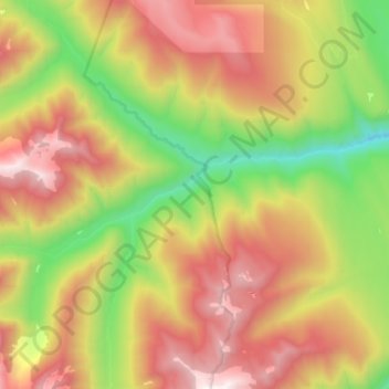
Name: Cooper Creek topographic map, elevation, terrain.
Average elevation: 1,573 m
Minimum elevation: 690 m
Maximum elevation: 2,526 m
Make a donation
Other topographic maps
Click on a map to view its topography, its elevation and its terrain.
Silent Pass
Canada > British Columbia > Regional District of Central Kootenay > Area D (Lardeau Valley/Duncan Lake)
Average elevation: 2,100 m
Ainsworth Hot Springs
Canada > British Columbia > Regional District of Central Kootenay > Area D (Lardeau Valley/Duncan Lake)
Average elevation: 741 m
Mount Nemo
Canada > British Columbia > Regional District of Central Kootenay > Area D (Lardeau Valley/Duncan Lake)
Average elevation: 2,283 m
Duncan Lake
Canada > British Columbia > Regional District of Central Kootenay > Area D (Lardeau Valley/Duncan Lake)
Average elevation: 1,658 m
Make a donation
Mazinaw Mountain
Canada > British Columbia > Regional District of Central Kootenay > Area D (Lardeau Valley/Duncan Lake)
Average elevation: 2,578 m