
Make a donation
Ainsworth Hot Springs topographic map
Click on the map to display elevation.
Make a donation
About this map
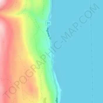
Name: Ainsworth Hot Springs topographic map, elevation, terrain.
Average elevation: 741 m
Minimum elevation: 520 m
Maximum elevation: 1,338 m
Make a donation
Other topographic maps
Click on a map to view its topography, its elevation and its terrain.
Cooper Creek
Canada > British Columbia > Regional District of Central Kootenay > Area D (Lardeau Valley/Duncan Lake)
Average elevation: 1,573 m
Keen Creek
Canada > British Columbia > Regional District of Central Kootenay > Area D (Lardeau Valley/Duncan Lake)
Average elevation: 976 m
Poplar Creek
Canada > British Columbia > Regional District of Central Kootenay > Area D (Lardeau Valley/Duncan Lake)
Average elevation: 1,732 m
Duncan Lake
Canada > British Columbia > Regional District of Central Kootenay > Area D (Lardeau Valley/Duncan Lake)
Average elevation: 1,658 m
Make a donation
Butters Lake
Canada > British Columbia > Regional District of Central Kootenay > Area D (Lardeau Valley/Duncan Lake)
Average elevation: 2,133 m