
Thank you for supporting this site ❤️
Make a donation
Make a donation
Gramais topographic map
Click on the map to display elevation.
Thank you for supporting this site ❤️
Make a donation
Make a donation
About this map
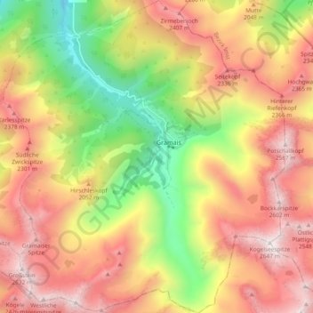
Name: Gramais topographic map, elevation, terrain.
Location: Gramais, Bezirk Reutte, Tyrol, 6650, Austria (47.23356 10.48601 47.29656 10.56974)
Average elevation: 1,918 m
Minimum elevation: 1,106 m
Maximum elevation: 2,621 m
Thank you for supporting this site ❤️
Make a donation
Make a donation
Other topographic maps
Click on a map to view its topography, its elevation and its terrain.