
Lüerdissen topographic map
Interactive map
Click on the map to display elevation.
About this map
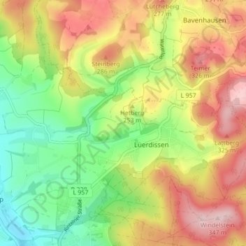
Name: Lüerdissen topographic map, elevation, terrain.
Location: Lüerdissen, Lemgo, Kreis Lippe, Nordrhein-Westfalen, Deutschland (52.05436 8.88608 52.07318 8.95427)
Average elevation: 220 m
Minimum elevation: 109 m
Maximum elevation: 345 m
Other topographic maps
Click on a map to view its topography, its elevation and its terrain.
Kirchheide
Deutschland > Nordrhein-Westfalen > Lemgo > Kirchheide
Kirchheide, Lemgo, Kreis Lippe, Nordrhein-Westfalen, Deutschland
Average elevation: 200 m