
Thank you for supporting this site ❤️
Make a donation
Make a donation
Hilders topographic map
Click on the map to display elevation.
Thank you for supporting this site ❤️
Make a donation
Make a donation
About this map
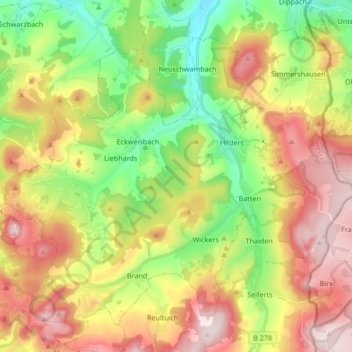
Name: Hilders topographic map, elevation, terrain.
Location: Hilders, Landkreis Fulda, Hessen, 36115, Duitsland (50.51667 9.89394 50.60707 10.06171)
Average elevation: 577 m
Minimum elevation: 381 m
Maximum elevation: 809 m
Thank you for supporting this site ❤️
Make a donation
Make a donation
Other topographic maps
Click on a map to view its topography, its elevation and its terrain.