
Churchill County topographic map
Interactive map
Click on the map to display elevation.
About this map
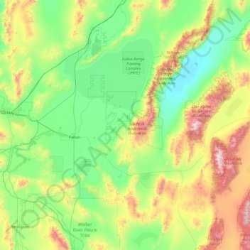
Name: Churchill County topographic map, elevation, terrain.
Location: Churchill County, Nevada, United States (39.07364 -119.22614 40.00304 -117.46018)
Average elevation: 1,476 m
Minimum elevation: 1,029 m
Maximum elevation: 3,027 m
The terrain of Churchill County consists of rugged mountainous ridges, dotted with lakes and ponds. The county's east and west sides are higher than the intermediate valley; its highest point around the county periphery is a ridge on the lower east boundary line, at 9,380' (2859m) ASL. The county has an area of 5,024 square miles (13,010 km2), of which 4,930 square miles (12,800 km2) is land and 94 square miles (240 km2) (1.9%) is water. The county's highest point is Desatoya Peak at 9,977' (3041m), while the most topographically prominent peak is Mount Augusta, at 9,970' (3039m) ASL.
Other topographic maps
Click on a map to view its topography, its elevation and its terrain.
Nellis Air Force Base
United States > Nevada > Clark County
Nellis Air Force Base, Clark County, Nevada, 89115, United States
Average elevation: 576 m
Grass Valley
United States > Nevada > Humboldt County
Grass Valley, Humboldt County, Nevada, United States
Average elevation: 1,329 m
Mud Springs
United States > Nevada > Lincoln County
Mud Springs, Lincoln County, Nevada, United States
Average elevation: 2,206 m
Las Vegas
United States > Nevada > Clark County
Las Vegas, Clark County, Nevada, United States
Average elevation: 756 m
Henderson
United States > Nevada > Clark County
Henderson, Clark County, Nevada, United States
Average elevation: 691 m
Whitney
United States > Nevada > Clark County
Whitney, Clark County, Nevada, 89112, United States
Average elevation: 524 m
Aurora Hill
United States > Nevada > Mineral County
Aurora Hill, Mineral County, Nevada, United States
Average elevation: 2,272 m
White Pine County
White Pine County, Nevada, United States
Average elevation: 2,049 m