
Cheshunt topographic map
Click on the map to display elevation.
About this map
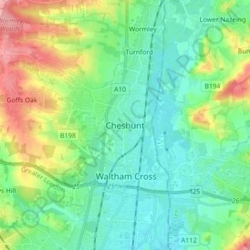
Name: Cheshunt topographic map, elevation, terrain.
Average elevation: 43 m
Minimum elevation: 14 m
Maximum elevation: 115 m
Other topographic maps
Click on a map to view its topography, its elevation and its terrain.
St Albans
United Kingdom > England > Hertfordshire > St Albans
St Albans was an ancient borough created following the dissolution of the monastery in 1539. It consisted of the ancient parish of St Albans (also known as the Abbey parish) and parts of St Michael and St Peter. The municipal corporation was reformed by the Municipal Corporations Act 1835 and the boundary was…
Average elevation: 100 m
Buntingford
United Kingdom > England > Hertfordshire > East Hertfordshire > Buntingford
Average elevation: 110 m
Bishop's Stortford
United Kingdom > England > Hertfordshire > East Hertfordshire > Thorley
Stortford, along with the rest of Britain, has a temperate maritime climate, with cool summers and mild winters. The nearest weather station for which averages and extremes are available is Stansted Airport, about 2+1⁄2 miles (4 kilometres) due east of Stortford's town centre. Located at an elevation of over…
Average elevation: 83 m
St Albans
United Kingdom > England > Hertfordshire
The borough consisted of the ancient parish of St Albans (also known as the Abbey parish) and parts of the parishes of St Michael and St Peter. The borough was reformed by the Municipal Corporations Act 1835 to become a municipal borough, and the boundary was adjusted to additionally include part of the parish…
Average elevation: 103 m
Highfield Park
United Kingdom > England > Hertfordshire > St Albans > Colney Heath
Average elevation: 87 m
Astonbury Wood
United Kingdom > England > Hertfordshire > East Hertfordshire > Aston
Average elevation: 83 m
Croxley Green
United Kingdom > England > Hertfordshire > Three Rivers > Rickmansworth
Average elevation: 67 m
St Albans
United Kingdom > England > Hertfordshire
St Albans was an ancient borough created following the dissolution of the monastery in 1539. It consisted of the ancient parish of St Albans (also known as the Abbey parish) and parts of St Michael and St Peter. The municipal corporation was reformed by the Municipal Corporations Act 1835 and the boundary was…
Average elevation: 107 m
Thorley
United Kingdom > England > Hertfordshire > East Hertfordshire > Thorley
Average elevation: 82 m
Sawbridgeworth
United Kingdom > England > Hertfordshire > East Hertfordshire > Sawbridgeworth
Average elevation: 67 m
Standon
United Kingdom > England > Hertfordshire > East Hertfordshire > Standon
Average elevation: 97 m
Newnham
United Kingdom > England > Hertfordshire > North Hertfordshire > Baldock
Average elevation: 69 m
Berkhamsted
United Kingdom > England > Hertfordshire > Dacorum > Northchurch
The layout of Berkhamsted's centre is typical of a medieval market settlement: the linear High Street (aligned on the Akeman Street) forms the spine of the town (roughly aligned east–west), from which extend medieval burgage plots (to the north and south). The surviving burgage plot layout is the result of a…
Average elevation: 142 m
Ellenbrook Fields
United Kingdom > England > Hertfordshire > Welwyn Hatfield > Hatfield
Average elevation: 80 m
Windmill Hill
United Kingdom > England > Hertfordshire > North Hertfordshire > Hitchin
Average elevation: 74 m
Saint Margarets Copse
United Kingdom > England > Hertfordshire > Dacorum > Great Gaddesden
Average elevation: 144 m
Mardley Heath
United Kingdom > England > Hertfordshire > Welwyn Hatfield > Oaklands
Average elevation: 110 m
Gobions Pond
United Kingdom > England > Hertfordshire > Welwyn Hatfield > Brookmans Park > Swanley Bar
Average elevation: 106 m
Tringford Reservoir
United Kingdom > England > Hertfordshire > Dacorum > Tring > Wilstone
Average elevation: 119 m
Knebworth Country Park
United Kingdom > England > Hertfordshire > North Hertfordshire > Knebworth
Average elevation: 116 m
King's Meads
United Kingdom > England > Hertfordshire > East Hertfordshire > Ware
Average elevation: 53 m
Furneux Pelham
United Kingdom > England > Hertfordshire > East Hertfordshire > Furneux Pelham
Average elevation: 113 m
Ware
United Kingdom > England > Hertfordshire > East Hertfordshire > Great Amwell
Average elevation: 55 m
Thundridge
United Kingdom > England > Hertfordshire > East Hertfordshire > High Cross
Average elevation: 78 m
The Rookery
United Kingdom > England > Hertfordshire > Three Rivers > Abbots Langley > Langleybury
Average elevation: 92 m
Stocking Pelham
United Kingdom > England > Hertfordshire > East Hertfordshire > Stocking Pelham
Average elevation: 114 m
Stanborough Park
United Kingdom > England > Hertfordshire > Welwyn Hatfield > Hatfield > Stanborough
Average elevation: 79 m
St Paul's Walden
United Kingdom > England > Hertfordshire > North Hertfordshire
Average elevation: 121 m
Little Berkhamsted
United Kingdom > England > Hertfordshire > East Hertfordshire
Average elevation: 88 m
Great Gaddesden
United Kingdom > England > Hertfordshire > Dacorum > Gaddesden Row
Average elevation: 146 m
Westbrook Mere
United Kingdom > England > Hertfordshire > Dacorum > Bourne End
Average elevation: 125 m
Ickleford
United Kingdom > England > Hertfordshire > North Hertfordshire > Hitchin
Average elevation: 58 m
Datchworth
United Kingdom > England > Hertfordshire > East Hertfordshire > Datchworth
Average elevation: 102 m