
Make a donation
San Fernando topographic map
Click on the map to display elevation.
Make a donation
About this map
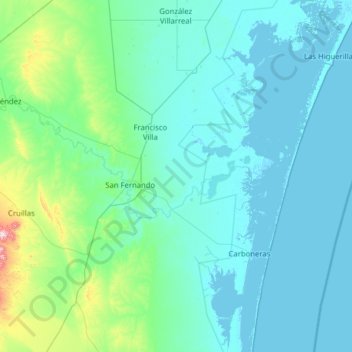
Name: San Fernando topographic map, elevation, terrain.
Location: San Fernando, Tamaulipas, Mexico (24.30054 -98.43041 25.44407 -97.51658)
Average elevation: 61 m
Minimum elevation: -3 m
Maximum elevation: 779 m
Make a donation
Other topographic maps
Click on a map to view its topography, its elevation and its terrain.
Make a donation
Make a donation
Ciudad Mante
Mexico > Tamaulipas > El Mante
El Cielo (The Heaven) a protected cloud forest covers a land mass of 144,530 hectares (~357,129 acres) and is a paradise for the great quantity of species that inhabit it. There are 175 distinct species of migratory birds and 225 local fowl, various amphibious and mammals, as well as white tail deer, jaguar…
Average elevation: 105 m
Make a donation
Make a donation
Ciudad Victoria
Mexico > Tamaulipas > Victoria
Ciudad Victoria has a climate on the border of humid subtropical (Köppen Cfa/Cwa) and hot semi-arid (BSh). Its weather is characterised by short warm winters and long hot to sweltering summers. Temperatures rarely drop below 0 °C (32 °F) — the lowest recorded temperature was −6 °C (21.2 °F) and the…
Average elevation: 518 m
Make a donation