
Chobe District topographic map
Interactive map
Click on the map to display elevation.
About this map
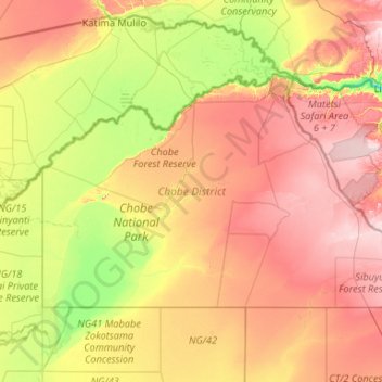
Name: Chobe District topographic map, elevation, terrain.
Location: Chobe District, Botswana (-19.00192 23.88218 -17.77814 25.98880)
Average elevation: 981 m
Minimum elevation: 896 m
Maximum elevation: 1,121 m
Kasane, Chobe National Park, Seboba Water Rapids, Pandamatenga Farms, Lesoma Memorial Monument, Kasane Hot Springs and Chobe River are the major tourist attractions in the district. Most part of Botswana has tableland slopes sliding from east to west. The region has an average elevation of around 915 m (3,002 ft) above the mean sea level. The vegetation type is Savannah, with tall grasses, bushes and trees. The annual precipitation is around 65 cm (26 in), most of which is received during the summer season from November to May. Most of the rivers in the region are seasonal, with Chobe River, which are prone to flash floods, being the most prominent. Chobe National Park is the second largest national park in the country and has the largest population of elephants in Africa. The district shares the international border of the country with Namibia and Zambia in the north, Zimbabwe in the east, and also the district borders along North-West district of the country.
Other topographic maps
Click on a map to view its topography, its elevation and its terrain.
Gaborone
Botswana > South-East District
Gaborone, South-East District, Botswana
Average elevation: 1,032 m
Maun
Botswana > North-West District > Maun
Maun, North-West District, P.O. BOX 217, Botswana
Average elevation: 942 m
Gaborone Dam
Botswana > South-East District > Gaborone
Gaborone Dam, Gaborone, South-East District, Botswana
Average elevation: 992 m