
Make a donation
El Porvenir topographic map
Click on the map to display elevation.
Make a donation
El Porvenir
Das Municipio El Porvenir liegt im Süden des mexikanischen Bundesstaats Chiapas auf Höhen zwischen 1200 m und 3100 m. Es zählt zur Gänze zur physiographischen Provinz der Cordillera Centroamericana und liegt gänzlich in der hydrologischen Region Grijalva-Usumacinta. Die Geologie des Municipios wird zu 90 % von schluffigem Sandstein bestimmt; vorherrschende Bodentypen sind der Regosol (65 %) und Acrisol (33 %). Etwa 41 % der Gemeindefläche sind bewaldet, 40 % dienen dem Ackerbau, 18 % werden von Weideland eingenommen.
Make a donation
About this map
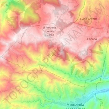
Name: El Porvenir topographic map, elevation, terrain.
Location: El Porvenir, Chiapas, Mexiko (15.38957 -92.34129 15.46839 -92.20377)
Average elevation: 2,237 m
Minimum elevation: 1,137 m
Maximum elevation: 3,074 m
Make a donation
Other topographic maps
Click on a map to view its topography, its elevation and its terrain.