
Thank you for supporting this site ❤️
Make a donation
Make a donation
Salzbergen topographic map
Click on the map to display elevation.
Thank you for supporting this site ❤️
Make a donation
Make a donation
About this map
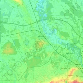
Name: Salzbergen topographic map, elevation, terrain.
Location: Salzbergen, Landkreis Emsland, Nedersaksen, 48499, Duitsland (52.28019 7.25739 52.35169 7.43800)
Average elevation: 39 m
Minimum elevation: 22 m
Maximum elevation: 83 m
Thank you for supporting this site ❤️
Make a donation
Make a donation
Other topographic maps
Click on a map to view its topography, its elevation and its terrain.
Thank you for supporting this site ❤️
Make a donation
Make a donation
Thank you for supporting this site ❤️
Make a donation
Make a donation
Thank you for supporting this site ❤️
Make a donation
Make a donation