
Styria topographic map
Click on the map to display elevation.
About this map
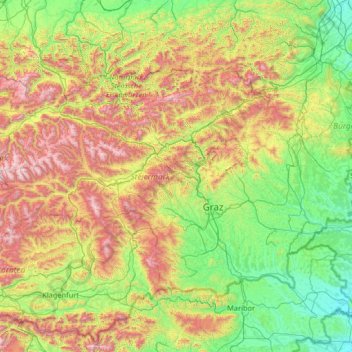
Name: Styria topographic map, elevation, terrain.
Location: Styria, Austria (46.61199 13.56335 47.82789 16.17178)
Average elevation: 767 m
Minimum elevation: 158 m
Maximum elevation: 2,579 m
Other topographic maps
Click on a map to view its topography, its elevation and its terrain.
Zöbing an der Raab
Austria > Styria > Bezirk Weiz > St. Margarethen an der Raab
Average elevation: 352 m