
Naninne topographic map
Interactive map
Click on the map to display elevation.
About this map
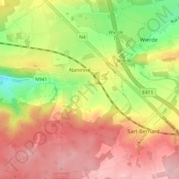
Name: Naninne topographic map, elevation, terrain.
Location: Naninne, Namur, Wallonie, 5100, Belgique (50.39433 4.90488 50.43456 4.94567)
Average elevation: 206 m
Minimum elevation: 111 m
Maximum elevation: 280 m
Other topographic maps
Click on a map to view its topography, its elevation and its terrain.
Saint-Servais
Saint-Servais, Namur, Wallonie, 5002, Belgique
Average elevation: 138 m
Le Tronquoy
Le Tronquoy, Namur, Wallonie, 5336, Belgique
Average elevation: 201 m