
Thank you for supporting this site ❤️
Make a donation
Make a donation
Hawke's Bay topographic map
Click on the map to display elevation.
Thank you for supporting this site ❤️
Make a donation
Make a donation
About this map
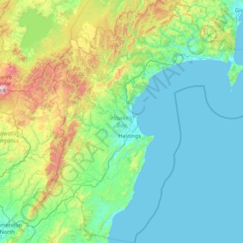
Name: Hawke's Bay topographic map, elevation, terrain.
Location: Hawke's Bay, New Zealand (-40.46708 176.04294 -38.58392 178.26304)
Average elevation: 338 m
Minimum elevation: 0 m
Maximum elevation: 2,716 m
Thank you for supporting this site ❤️
Make a donation
Make a donation
Other topographic maps
Click on a map to view its topography, its elevation and its terrain.
Thank you for supporting this site ❤️
Make a donation
Make a donation
Christmas Village
New Zealand > Southland > Southland District > Stewart Island / Rakiura Community
Average elevation: 85 m
Murray Beach
New Zealand > Southland > Southland District > Stewart Island / Rakiura Community
Average elevation: 48 m
Thank you for supporting this site ❤️
Make a donation
Make a donation
Merrivale
New Zealand > Southland > Southland District > Tuatapere Te Waewae Community
Average elevation: 192 m
Thank you for supporting this site ❤️
Make a donation
Make a donation
Castle Hill
New Zealand > Southland > Southland District > Northern Community
Average elevation: 569 m
Thank you for supporting this site ❤️
Make a donation
Make a donation