
Hengistbury Head topographic map
Interactive map
Click on the map to display elevation.
About this map
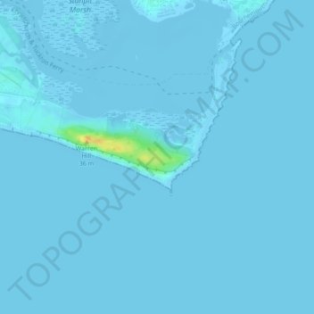
Name: Hengistbury Head topographic map, elevation, terrain.
Average elevation: 0 m
Minimum elevation: -4 m
Maximum elevation: 27 m
In 1910 the first international aviation meeting ever held in Britain took place on a specially laid out aerodrome consisting of a mile of grassland between the "Double Dykes" and the nearby village of Tuckton. About twenty pioneer aviators from around the world participated in various competitions including spot landing, altitude tests and speed trials (both for the fastest and slowest circuit).
Other topographic maps
Click on a map to view its topography, its elevation and its terrain.
Bournemouth
United Kingdom > England > Bournemouth, Christchurch and Poole > Wick
Bournemouth, Wick, Bournemouth, Christchurch and Poole, England, United Kingdom
Average elevation: 17 m
Poole
United Kingdom > England > Bournemouth, Christchurch and Poole > Poole
Poole, Bournemouth, Christchurch and Poole, England, United Kingdom
Average elevation: 23 m
Christchurch
United Kingdom > England > Bournemouth, Christchurch and Poole > Hurn
Christchurch, Hurn, Bournemouth, Christchurch and Poole, England, United Kingdom
Average elevation: 18 m
East Parley Common
United Kingdom > England > Bournemouth, Christchurch and Poole > Hurn
East Parley Common, Hurn, Bournemouth, Christchurch and Poole, England, United Kingdom
Average elevation: 13 m
Bournemouth
United Kingdom > England > Bournemouth, Christchurch and Poole
Bournemouth, Bournemouth, Christchurch and Poole, England, BH2 6EG, United Kingdom
Average elevation: 21 m
Poole
United Kingdom > England > Bournemouth, Christchurch and Poole
Poole, Bournemouth, Christchurch and Poole, England, BH15 1SU, United Kingdom
Average elevation: 16 m
Merley
United Kingdom > England > Bournemouth, Christchurch and Poole
Merley, Bournemouth, Christchurch and Poole, England, BH21 3AQ, United Kingdom
Average elevation: 34 m
Holes Bay
United Kingdom > England > Bournemouth, Christchurch and Poole > Poole
Holes Bay, Sterte, Poole, Bournemouth, Christchurch and Poole, South West England, England, BH15 2BD, United Kingdom
Average elevation: 4 m
Upton Heath Nature Reserve
United Kingdom > England > Bournemouth, Christchurch and Poole > Poole
Upton Heath Nature Reserve, Lytchett Minster and Upton, Poole, Bournemouth, Christchurch and Poole, South West England, England, BH17 7BQ, United Kingdom
Average elevation: 40 m
Kinson
United Kingdom > England > Bournemouth, Christchurch and Poole
Kinson, Bournemouth, Christchurch and Poole, England, BH10 7AY, United Kingdom
Average elevation: 26 m
Christchurch
United Kingdom > England > Bournemouth, Christchurch and Poole > Christchurch
Christchurch, Bournemouth, Christchurch and Poole, South West England, England, United Kingdom
Average elevation: 8 m
Hurn
United Kingdom > England > Bournemouth, Christchurch and Poole
Hurn, Bournemouth, Christchurch and Poole, England, United Kingdom
Average elevation: 12 m
Talbot Village
United Kingdom > England > Bournemouth, Christchurch and Poole
Talbot Village, Bournemouth, Christchurch and Poole, England, BH10 4JA, United Kingdom
Average elevation: 40 m
Wick
United Kingdom > England > Bournemouth, Christchurch and Poole
Wick, Bournemouth, Christchurch and Poole, England, BH6 4LP, United Kingdom
Average elevation: 4 m
Highcliffe-on-Sea
United Kingdom > England > Bournemouth, Christchurch and Poole
Highcliffe-on-Sea, Bournemouth, Christchurch and Poole, England, BH23 5GD, United Kingdom
Average elevation: 19 m