
Thank you for supporting this site ❤️
Make a donation
Make a donation
Upton Heath Nature Reserve topographic map
Click on the map to display elevation.
Thank you for supporting this site ❤️
Make a donation
Make a donation
About this map
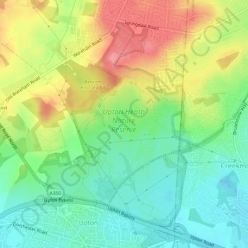
Name: Upton Heath Nature Reserve topographic map, elevation, terrain.
Average elevation: 40 m
Minimum elevation: 4 m
Maximum elevation: 89 m
Thank you for supporting this site ❤️
Make a donation
Make a donation
Other topographic maps
Click on a map to view its topography, its elevation and its terrain.
Holes Bay
United Kingdom > England > Bournemouth, Christchurch and Poole > Poole
Average elevation: 4 m