
Nashik topographic map
Click on the map to display elevation.
Nashik
The city's tropical location and high altitude combine to give it a relatively mild version of a hot semi-arid climate (Köppen BSh). Temperatures rise slightly in October, but this is followed by the cool season from November to February. The cool season sees warm temperatures of around 28 °C or 82.4 °F during the day, but cool nights, with lows averaging 10 °C or 50 °F, and extremely dry air.
About this map
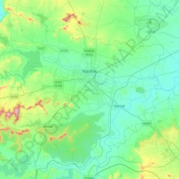
Name: Nashik topographic map, elevation, terrain.
Location: Nashik, Maharashtra, India (19.80421 73.55663 20.14023 73.95585)
Average elevation: 631 m
Minimum elevation: 523 m
Maximum elevation: 1,064 m
Other topographic maps
Click on a map to view its topography, its elevation and its terrain.
Solapur
India > Maharashtra > Solapur North
Solapur is located at 17°41′N 75°55′E / 17.68°N 75.92°E / 17.68; 75.92. It has an average elevation of 458 metres (1502 feet). It is bordered by Ahmednagar district on the north; Osmanabad district on the north and northeast.
Average elevation: 469 m
Malkapur
India > Maharashtra > Shahuwadi
Malkapur is located at 16°56′N 73°55′E / 16.93°N 73.92°E / 16.93; 73.92. It has an average elevation of 586 metres (1922 feet).
Average elevation: 581 m
Sangamner
India > Maharashtra > Sangamner
Sangamner is located at 19°34′N 74°13′E / 19.57°N 74.22°E / 19.57; 74.22, on the banks of the Pravara River. It has an average elevation of 549 metres (1,801 ft)from mean sea level. Sangamner is the biggest settlement on NH 50 (New NH-60) between Pune (143 km distance) and Nashik (69 km…
Average elevation: 566 m
Goregaon
India > Maharashtra > Mangaon Taluka
Goregaon is located in the south-west of India at 18°10′N 73°18′E / 18.17°N 73.3°E / 18.17; 73.3. The average elevation is 28 metres (92 ft).
Average elevation: 38 m
Pench (Indira Priyadarsini) National Park/Tiger Reserve
India > Maharashtra > Ramtek Taluka
Average elevation: 485 m