
Vermes topographic map
Interactive map
Click on the map to display elevation.
About this map
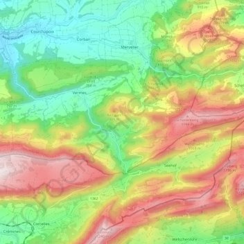
Name: Vermes topographic map, elevation, terrain.
Location: Vermes, Val Terbi, District de Delémont, Jura, 2829, Suisse (47.30195 7.44017 47.33637 7.55834)
Average elevation: 816 m
Minimum elevation: 472 m
Maximum elevation: 1,270 m
Other topographic maps
Click on a map to view its topography, its elevation and its terrain.
La Scheulte
La Scheulte, Val Terbi, District de Delémont, Jura, 2824, Suisse
Average elevation: 604 m