
Herstal topographic map
Interactive map
Click on the map to display elevation.
About this map
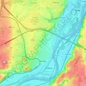
Name: Herstal topographic map, elevation, terrain.
Location: Herstal, Luik, Wallonië, 4040, België (50.65470 5.55531 50.70246 5.65705)
Average elevation: 113 m
Minimum elevation: 53 m
Maximum elevation: 219 m
De stad ligt in het laagterras van de Maas, op een hoogte van ongeveer 70 meter. Naar het westen toe neemt de hoogte toe tot 145 meter, en is men in Haspengouw. In het noorden wordt Herstal begrensd door de autoweg A3. De Spoorlijn 34 doorsnijdt Herstal.
Other topographic maps
Click on a map to view its topography, its elevation and its terrain.
Plainevaux
Plainevaux, Neupré, Luik, Wallonië, 4120, België
Average elevation: 219 m
Villers-Saint-Siméon
België > Luik > Luik > Villers-Saint-Siméon
Villers-Saint-Siméon, Luik, Wallonië, 4453, België
Average elevation: 152 m
Grâce-Hollogne
België > Luik > Luik > Grâce-Hollogne
Grâce-Hollogne, Luik, Wallonië, 4460, België
Average elevation: 143 m
Remouchamps
België > Luik > Luik > Aywaille
Remouchamps, Aywaille, Luik, Wallonië, 4920, België
Average elevation: 222 m
Embourg
België > Luik > Luik > Chaudfontaine
Embourg, Chaudfontaine, Luik, Wallonië, 4050, België
Average elevation: 139 m
Chaudfontaine
Chaudfontaine, Luik, Wallonië, 4050, België
Average elevation: 188 m
Rotheux-Rimière
België > Luik > Luik > Rotheux-Rimière
Rotheux-Rimière, Neupré, Luik, Wallonië, 4120, België
Average elevation: 233 m