
Berneau topographic map
Interactive map
Click on the map to display elevation.
About this map
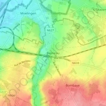
Name: Berneau topographic map, elevation, terrain.
Location: Berneau, Dalhem, Luik, Wallonië, 4607, België (50.72234 5.71125 50.76234 5.75125)
Average elevation: 98 m
Minimum elevation: 55 m
Maximum elevation: 148 m
Berneau ligt in het weidegebied van het Land van Herve op een hoogte van ongeveer 75 meter. Door Berneau stroomt de Berwijn in noordelijke richting.