
La Fouly topographic map
Interactive map
Click on the map to display elevation.
About this map
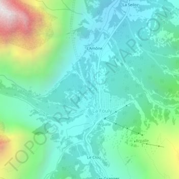
Name: La Fouly topographic map, elevation, terrain.
Location: La Fouly, Orsières, Entremont, Valais, 2303, Suisse (45.93622 7.09604 45.93633 7.09660)
Average elevation: 1,840 m
Minimum elevation: 1,485 m
Maximum elevation: 2,962 m
Other topographic maps
Click on a map to view its topography, its elevation and its terrain.
Aiguille d'Argentière
Aiguille d'Argentière, Orsières, Entremont, Valais, 2303, Suisse
Average elevation: 3,282 m
Glacier d'Orny
Glacier d'Orny, par la Moraine, La Deuve, Orsières, Entremont, Valais, 2303, Suisse
Average elevation: 2,921 m