
Make a donation
Morgan's Point Resort topographic map
Click on the map to display elevation.
Make a donation
About this map
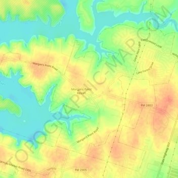
Name: Morgan's Point Resort topographic map, elevation, terrain.
Location: Morgan's Point Resort, Bell County, Texas, United States (31.13233 -97.48723 31.16511 -97.43569)
Average elevation: 201 m
Minimum elevation: 175 m
Maximum elevation: 224 m
Make a donation
Other topographic maps
Click on a map to view its topography, its elevation and its terrain.
Belton
United States > Texas > Bell County > Belton > Belton
Belton is located 60 miles (97 km) north of Austin, 137 miles (220 km) south of Dallas, and 184 miles (296 km) west of Houston. It is near the center of Bell County at 31°3′32″N 97°27′48″W / 31.05889°N 97.46333°W / 31.05889; -97.46333 (31.058904, -97.463382). It is at the point where the…
Average elevation: 176 m
Make a donation
Belton
United States > Texas > Bell County
Belton is located 60 miles (97 km) north of Austin, 137 miles (220 km) south of Dallas, and 184 miles (296 km) west of Houston. It is near the center of Bell County at 31°3′32″N 97°27′48″W / 31.05889°N 97.46333°W / 31.05889; -97.46333 (31.058904, –97.463382). Belton is at the point where…
Average elevation: 179 m
Morgans Point Resort
United States > Texas > Bell County > Morgans Point Resort
Average elevation: 201 m
Make a donation