
Dorchester County topographic map
Interactive map
Click on the map to display elevation.
About this map
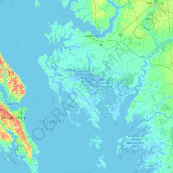
Name: Dorchester County topographic map, elevation, terrain.
Location: Dorchester County, Maryland, USA (38.05895 -76.43666 38.70409 -75.70157)
Average elevation: 3 m
Minimum elevation: -4 m
Maximum elevation: 41 m
Other topographic maps
Click on a map to view its topography, its elevation and its terrain.
Ferry Road
USA > Maryland > Ferry Road
Ferry Road, Wicomico County, Maryland, 21810, USA
Average elevation: 7 m
Cockeysville
USA > Maryland > Cockeysville
Cockeysville, Baltimore County, Maryland, 21031, USA
Average elevation: 131 m
Grahams Green Acres
USA > Maryland > Grahams Green Acres
Grahams Green Acres, Carroll County, Maryland, 21776, USA
Average elevation: 223 m
Bel Air South
USA > Maryland > Bel Air South
Bel Air South, Harford County, Maryland, USA
Average elevation: 81 m