
Thank you for supporting this site ❤️
Make a donation
Make a donation
Woodbine topographic map
Click on the map to display elevation.
Thank you for supporting this site ❤️
Make a donation
Make a donation
About this map
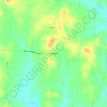
Name: Woodbine topographic map, elevation, terrain.
Location: Woodbine, Cooke County, Texas, United States (33.59066 -97.03556 33.63066 -96.99556)
Average elevation: 233 m
Minimum elevation: 215 m
Maximum elevation: 258 m
Thank you for supporting this site ❤️
Make a donation
Make a donation
Other topographic maps
Click on a map to view its topography, its elevation and its terrain.
Thank you for supporting this site ❤️
Make a donation
Make a donation
Thank you for supporting this site ❤️
Make a donation
Make a donation