
Make a donation
Witvlei topographic map
Click on the map to display elevation.
Make a donation
About this map
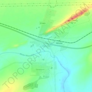
Name: Witvlei topographic map, elevation, terrain.
Location: Witvlei, Namibia (-22.43096 18.47234 -22.39096 18.51234)
Average elevation: 1,459 m
Minimum elevation: 1,437 m
Maximum elevation: 1,504 m
Make a donation
Other topographic maps
Click on a map to view its topography, its elevation and its terrain.
Windhoek
Windhoek has over 300 sunny days per year. It experiences a hot semi-arid climate (BSh) according to Köppen climate classification as the annual average temperature is above 18 °C (64 °F). The temperature throughout the year would be called mild, due to altitude influence. The annual average high and low…
Average elevation: 1,679 m
Make a donation
Make a donation
Make a donation
Make a donation
Windhoek
Windhoek has over 300 sunny days per year. It experiences a hot semi-arid climate (BSh) according to Köppen climate classification as the annual average temperature is above 18 °C (64 °F). The temperature throughout the year would be called mild, due to altitude influence. The annual average high and low…
Average elevation: 1,710 m
Make a donation
Tsumeb
Near the town are two large sinkhole lakes, Lake Otjikoto and Lake Guinas ("Gwee-nus"). Guinas, at about 500 m in diameter, is somewhat larger in area than Otjikoto. A pioneering documentary movie about scuba diving in these lakes was made by Graham Ferreira in the early 1970s. The depths of the lakes are…
Average elevation: 1,310 m
Make a donation
Windhoek
Windhoek has over 300 sunny days per year. It experiences a hot semi-arid climate (BSh) according to Köppen climate classification as the annual average temperature is above 18 °C (64 °F). The temperature throughout the year would be called mild, due to altitude influence. The annual average high and low…
Average elevation: 1,710 m
Make a donation
Rehoboth
Rehoboth is a town in central Namibia just north of the Tropic of Capricorn. Located 90 kilometres (55 miles) south of the Namibian capital Windhoek, Rehoboth lies on a high elevation plateau with several natural hot-water springs. It receives sparse mean annual rainfall of 240 millimetres (9.4 in), although…
Average elevation: 1,408 m
Make a donation
Windhoek
Windhoek has over 300 sunny days per year. It experiences a hot semi-arid climate (BSh) according to Köppen climate classification as the annual average temperature is above 18 °C (64 °F). The temperature throughout the year would be called mild, due to altitude influence. The annual average high and low…
Average elevation: 1,679 m
Make a donation
Windhoek
Windhoek has over 300 sunny days per year. It experiences a hot semi-arid climate (BSh) according to Köppen climate classification as the annual average temperature is above 18 °C (64 °F). The temperature throughout the year would be called mild, due to altitude influence. The annual average high and low…
Average elevation: 1,710 m
Make a donation
Make a donation
Make a donation
Make a donation
Make a donation
Make a donation