
Thank you for supporting this site ❤️
Make a donation
Make a donation
Otjozondjupa topographic map
Click on the map to display elevation.
Thank you for supporting this site ❤️
Make a donation
Make a donation
About this map
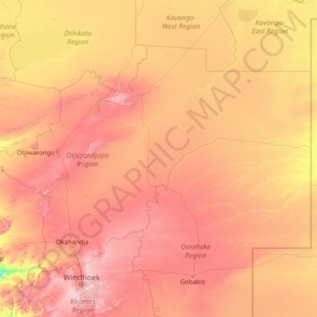
Name: Otjozondjupa topographic map, elevation, terrain.
Location: Otjozondjupa, Namibia (-22.37878 15.57246 -18.74754 20.99902)
Average elevation: 1,308 m
Minimum elevation: 739 m
Maximum elevation: 2,311 m
Thank you for supporting this site ❤️
Make a donation
Make a donation
Other topographic maps
Click on a map to view its topography, its elevation and its terrain.