
Make a donation
Somerdale topographic map
Click on the map to display elevation.
Make a donation
About this map
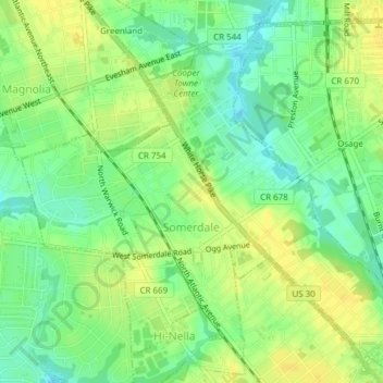
Name: Somerdale topographic map, elevation, terrain.
Location: Somerdale, Camden County, New Jersey, 08083, United States (39.83411 -75.03961 39.85935 -75.00158)
Average elevation: 23 m
Minimum elevation: 11 m
Maximum elevation: 32 m
Make a donation
Other topographic maps
Click on a map to view its topography, its elevation and its terrain.
Make a donation
Columbia Lakes
United States > New Jersey > Camden County > Cherry Hill Township
Average elevation: 17 m
Charleston East
United States > New Jersey > Camden County > Cherry Hill Township
Average elevation: 23 m
Make a donation
Haddon Towne
United States > New Jersey > Camden County > Cherry Hill Township
Average elevation: 20 m
Stoys Landing
United States > New Jersey > Camden County > Cherry Hill Township
Average elevation: 14 m
Make a donation
Make a donation
Andrews
United States > New Jersey > Camden County > Winslow Township > Sicklerville
Average elevation: 40 m
Make a donation
Make a donation
Make a donation
Cherry Valley
United States > New Jersey > Camden County > Cherry Hill Township > Cherry Valley
Average elevation: 16 m