
Shinano River topographic map
Interactive map
Click on the map to display elevation.
About this map
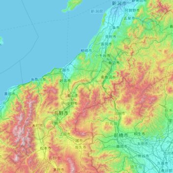
Name: Shinano River topographic map, elevation, terrain.
Location: Shinano River, 940-0093, Japan (35.94338 138.10594 37.94765 139.07165)
Average elevation: 565 m
Minimum elevation: -7 m
Maximum elevation: 3,055 m
The Chikuma River originates in the Japanese Alps at altitudes of above 2,000 metres (6,600 ft) and has a basin in its own right of 7,163 square kilometres (2,766 sq mi). The Chikuma continues generally north-northeast joining with the Sai and changing name to the Shinano, after 214 kilometres (133 mi). The Chikuma, therefore, includes around sixty percent of the whole river system's basin and around 58 percent of the river's length.
Other topographic maps
Click on a map to view its topography, its elevation and its terrain.
Mt. Fuji
Japan > Sunto County > Oyama
Mt. Fuji, Oyama, Sunto County, Shizuoka Prefecture, Chubu Region, Japan
Average elevation: 3,261 m
Kutchan
Kutchan, Abuta County, Shiribeshi Subprefecture, Hokkaido Prefecture, Japan
Average elevation: 374 m
Yamanouchi
Yamanouchi, Shimotakai County, Nagano Prefecture, Chubu Region, Japan
Average elevation: 942 m
Wadomari
Wadomari, Oshima County, Kagoshima Prefecture, Japan
Average elevation: 3 m
Taku-shima Island
Taku-shima Island, Hirado, Nagasaki Prefecture, Japan
Average elevation: 8 m
Hara
Japan > Suwa County > Hara
Hara, Suwa County, Nagano Prefecture, 391-0104, Japan
Average elevation: 1,235 m
Toyohashi
Toyohashi, Aichi Prefecture, Chubu Region, Japan
Average elevation: 17 m