
Saitama Prefecture topographic map
Interactive map
Click on the map to display elevation.
About this map
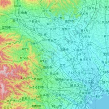
Name: Saitama Prefecture topographic map, elevation, terrain.
Location: Saitama Prefecture, Japan (35.75338 138.71136 36.28341 139.90033)
Average elevation: 230 m
Minimum elevation: -3 m
Maximum elevation: 2,041 m
The topography of Saitama Prefecture is largely divided by the Hachiōji Tectonic Line, which runs through Kodama, Ogawa, and Hannō, into the western mountain area and the eastern lowland area. The altitude, highest on the western side, gradually lowers eastward from mountain ranges to hills to plateaus to lowlands. The eastern lowlands and plateaus occupy 67.3% of the area.
Other topographic maps
Click on a map to view its topography, its elevation and its terrain.
Mt. Fuji
Japan > Sunto County > Oyama
Mt. Fuji, Oyama, Sunto County, Shizuoka Prefecture, Chubu Region, Japan
Average elevation: 3,261 m
Kutchan
Kutchan, Abuta County, Shiribeshi Subprefecture, Hokkaido Prefecture, Japan
Average elevation: 374 m
Yamanouchi
Yamanouchi, Shimotakai County, Nagano Prefecture, Chubu Region, Japan
Average elevation: 942 m
Wadomari
Wadomari, Oshima County, Kagoshima Prefecture, Japan
Average elevation: 3 m
Taku-shima Island
Taku-shima Island, Hirado, Nagasaki Prefecture, Japan
Average elevation: 8 m
Hara
Japan > Suwa County > Hara
Hara, Suwa County, Nagano Prefecture, 391-0104, Japan
Average elevation: 1,235 m
Toyohashi
Toyohashi, Aichi Prefecture, Chubu Region, Japan
Average elevation: 17 m