
Chuncheon-si topographic map
Interactive map
Click on the map to display elevation.
About this map
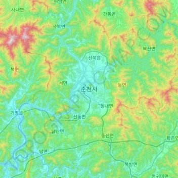
Name: Chuncheon-si topographic map, elevation, terrain.
Location: Chuncheon-si, Gangwon-do, South Korea (37.67560 127.50681 38.08526 128.02994)
Average elevation: 317 m
Minimum elevation: 44 m
Maximum elevation: 1,447 m
Other topographic maps
Click on a map to view its topography, its elevation and its terrain.
Gangwon
South Korea > Gangwon-do > Chuncheon-si > Bongui-dong
Gangwon, Mosumul-gil, Bongui-dong, Chuncheon-si, Gangwon-do, 24267, South Korea
Average elevation: 95 m
saebong
South Korea > Gangwon-do > Pyeongchang-gun
saebong, Pyeongchang-gun, Gangwon-do, South Korea
Average elevation: 893 m