
Masbate Island topographic map
Interactive map
Click on the map to display elevation.
About this map
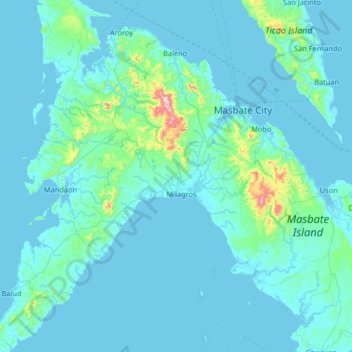
Name: Masbate Island topographic map, elevation, terrain.
Location: Masbate Island, Masbate, Bicol Region, 5410, Philippines (11.93000 123.18000 12.57000 123.82000)
Average elevation: 40 m
Minimum elevation: -4 m
Maximum elevation: 669 m
Other topographic maps
Click on a map to view its topography, its elevation and its terrain.
Jintotolo Island
Philippines > Masbate > Jintotolo
Its elevation was recorded at around 120 feet (37 m) in 1919. A lighthouse with a tower at 51 feet (16 m) in height exists on Jintotolo island.
Average elevation: 6 m