
Zamboanga City topographic map
Interactive map
Click on the map to display elevation.
About this map
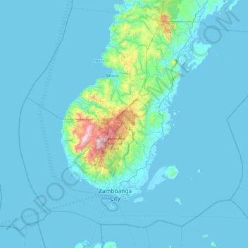
Name: Zamboanga City topographic map, elevation, terrain.
Location: Zamboanga City, Zamboanga Peninsula, 7000, Philippines (6.79728 121.75970 7.46891 122.57391)
Average elevation: 78 m
Minimum elevation: -2 m
Maximum elevation: 1,317 m
Other topographic maps
Click on a map to view its topography, its elevation and its terrain.
Zamboanga City
Philippines > Zamboanga Peninsula > Zamboanga City
The overall topography of the city could be described as rolling to very steep. There are some flat lands, mostly narrow strips along the east coast. The urban center is mostly flat with a gentle slope to the interior, ranging from 0 to 3%. The highest registered elevation is 1,200 metres. In terms of slope, a…
Average elevation: 83 m