
General Tinio topographic map
Interactive map
Click on the map to display elevation.
General Tinio
Farming is the livelihood of majority of the residents. Even though located at the foot of the Sierra Madre Mountain Ridges, the topography is generally plain ideal to agricultural products such as palay and vegetables. A number of poultry broiler contract growers are located in the municipality. Other industries include furniture and fixtures, backyard poultry, cattle and livestock, vegetable production and minor agricultural livelihoods like duck raising. "Ikmo" or betel leaves production is one dying symbol of the town. The practice of chewing betel leaves by the older generation was not adopted by the younger generation even though of its reported natural anti-cancer formula.
About this map
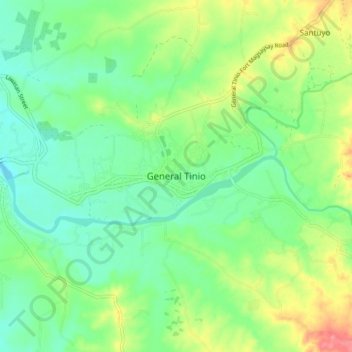
Name: General Tinio topographic map, elevation, terrain.
Location: General Tinio, Nueva Ecija, Central Luzon, 3104, Philippines (15.31013 121.00980 15.39013 121.08980)
Average elevation: 54 m
Minimum elevation: 28 m
Maximum elevation: 104 m
Other topographic maps
Click on a map to view its topography, its elevation and its terrain.
Lupao
Lupao belongs to the first type of climate in the Philippines. This type of climate has two (2) pronounced seasons: dry from the month of November to April and Wet during the rest of the year. This type of climate is typically hot, humid and tropical and is generally affected by the neighboring topography and…
Average elevation: 175 m
Muñoz
Muñoz is situated 30 kilometres (19 mi) from Cabanatuan, 44 kilometres (27 mi) from Palayan, and 146 kilometres (91 mi) north of the capital Manila. Due to its rich topography and tropical climate, it is now home to agricultural research and technology centers, committed to the production of information and…
Average elevation: 72 m
Licab
About 155 kilometres (96 mi) north of Metro Manila, Licab lies in one of the lowest portions of the province with an average elevation of 24 metres (79 ft), experiencing flooding in all but one of its 11 barangays during rainy season.
Average elevation: 22 m
Lupao
Lupao belongs to the first type of climate in the Philippines. This type of climate has two (2) pronounced seasons: dry from the month of November to April and Wet during the rest of the year. This type of climate is typically hot, humid and tropical and is generally affected by the neighboring topography and…
Average elevation: 175 m
Nueva Ecija Old Provincial Capitol Plaza
Philippines > Nueva Ecija > Cabanatuan > Isla
Average elevation: 34 m
Pantabangan Dam
Philippines > Nueva Ecija > Pantabangan > Fatima
The dam is a 107 m (351 ft) tall and 1,615 m (5,299 ft) long embankment-type with 12,000,000 cu yd (9,174,658 m3) of homogeneous earth-fill and an impervious core. The crest of the dam is 12 m (39 ft) wide while the widest part of its base is 535 m (1,755 ft). The dam's crest sits at an elevation of 232 m (761…
Average elevation: 210 m
Muñoz
Muñoz is situated 30 kilometres (19 mi) from Cabanatuan, 44 kilometres (27 mi) from Palayan, and 146 kilometres (91 mi) north of the capital Manila. Due to its rich topography and tropical climate, it is now home to agricultural research and technology centers, committed to the production of information and…
Average elevation: 72 m
Muñoz
It is situated 30 kilometres (19 mi) from Cabanatuan, 44 kilometres (27 mi) from Palayan, and 146 kilometres (91 mi) north of the capital Manila. Due to its rich topography and tropical climate, it is now home to agricultural research and technology centers, committed to the production of information and…
Average elevation: 72 m
San Jose
The city of San Jose lies at 15° 47' North, 120° 59' East in Central Luzon. The estimated elevation at these coordinates is approximately 109.9 meters or 360.4 feet above mean sea level.
Average elevation: 147 m
Talavera
The municipality's terrain is relatively flat, with slope ranging from 0 to 3%. Due to the flat topography, the land is suited for agricultural, commercial or industrial development. It is bordered by Cabanatuan, Llanera, Muñoz, Aliaga, General Mamerto Natividad, Santo Domingo and San Jose.
Average elevation: 49 m