
Libertad topographic map
Interactive map
Click on the map to display elevation.
About this map
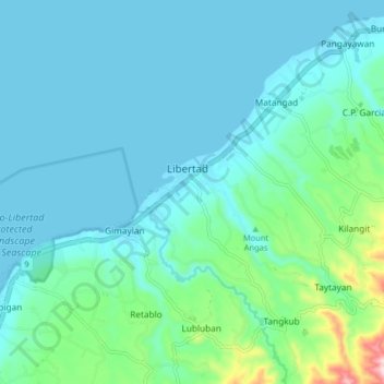
Name: Libertad topographic map, elevation, terrain.
Location: Libertad, Misamis Oriental, Northern Mindanao, Philippines (8.52270 124.31227 8.60270 124.39227)
Average elevation: 42 m
Minimum elevation: -1 m
Maximum elevation: 302 m
Other topographic maps
Click on a map to view its topography, its elevation and its terrain.
Cagayan de Oro River
Philippines > Misamis Oriental > Cagayan De Oro > Balulang
Average elevation: 98 m