
Ticao Island topographic map
Interactive map
Click on the map to display elevation.
About this map
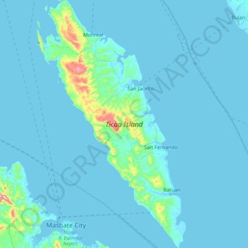
Name: Ticao Island topographic map, elevation, terrain.
Location: Ticao Island, Masbate, Bicol Region, 5417, Philippines (12.33834 123.57895 12.69393 123.80052)
Average elevation: 23 m
Minimum elevation: -1 m
Maximum elevation: 411 m
Other topographic maps
Click on a map to view its topography, its elevation and its terrain.
Jintotolo Island
Philippines > Masbate > Jintotolo
Its elevation was recorded at around 120 feet (37 m) in 1919. A lighthouse with a tower at 51 feet (16 m) in height exists on Jintotolo island.
Average elevation: 6 m