
Kamchatka Krai topographic map
Interactive map
Click on the map to display elevation.
About this map
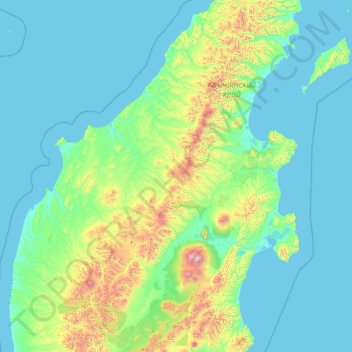
Name: Kamchatka Krai topographic map, elevation, terrain.
Location: Kamchatka Krai, Far Eastern Federal District, Russia (54.63149 157.47838 59.75149 162.59838)
Average elevation: 224 m
Minimum elevation: -4 m
Maximum elevation: 4,407 m
Other topographic maps
Click on a map to view its topography, its elevation and its terrain.
Kurile Lake
Russia > Kamchatka Krai > Ust-Bolsheretsky District
Kurile Lake is formed by two basins, which are separated by a 150-metre-wide (490 ft) subaqueous ridge. The center part of the lake is formed by a flat basin; canyons cut into the slopes of the western side of the lake, where the Ozernaya and Kumnynk rivers open into the lake. The Etamynk and Khakytsin rivers…
Average elevation: 175 m