
Crook County topographic map
Interactive map
Click on the map to display elevation.
About this map
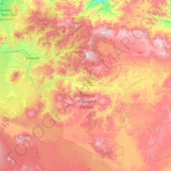
Name: Crook County topographic map, elevation, terrain.
Location: Crook County, Oregon, United States (43.69748 -121.10864 44.56395 -119.65489)
Average elevation: 1,339 m
Minimum elevation: 614 m
Maximum elevation: 2,099 m
Other topographic maps
Click on a map to view its topography, its elevation and its terrain.
Sandy
United States > Oregon > Clackamas County
Sandy, Clackamas County, Oregon, 97055, United States
Average elevation: 247 m
Portland
United States > Oregon > Multnomah County
Portland, Multnomah County, Oregon, United States
Average elevation: 77 m
Oregon City
United States > Oregon > Clackamas County
Oregon City, Clackamas County, Oregon, 97045, United States
Average elevation: 99 m
Bend
United States > Oregon > Deschutes County
Bend, Deschutes County, Oregon, United States
Average elevation: 1,121 m
Ashland
United States > Oregon > Jackson County
Ashland, Jackson County, Oregon, United States
Average elevation: 774 m
Eugene
United States > Oregon > Lane County
Eugene, Lane County, Oregon, United States
Average elevation: 163 m
Hillsboro
United States > Oregon > Washington County
Hillsboro, Washington County, Oregon, United States
Average elevation: 53 m
Deschutes County
Deschutes County, Oregon, United States
Average elevation: 1,324 m
Hood River County
Hood River County, Oregon, United States
Average elevation: 860 m
Mount Mazama
United States > Oregon > Klamath County
Mount Mazama, Klamath County, Oregon, United States
Average elevation: 1,880 m