Geolocate

Trece Martires topographic map

Interactive map

Click on the map to display elevation.

Trece Martires

The city of Trece Martires is characterised with ground elevation ranging from 30 metres (98 ft) to nearly 400 metres (1,300 ft). Its ground slope ranges from 0.5 to 2%.

Wikipedia (CC-BY-SA 3.0)

About this map

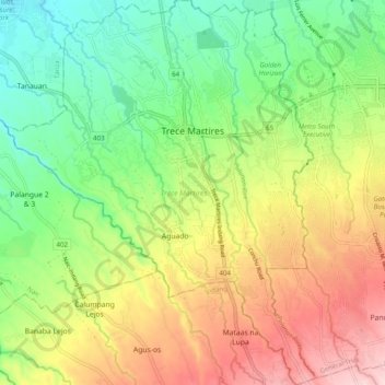
Name: Trece Martires topographic map, elevation, terrain.

Location: Trece Martires, Cavite, Calabarzon, 4109, Philippines (14.21817 120.82293 14.31350 120.90154)

Average elevation: 142 m

Minimum elevation: 36 m

Maximum elevation: 286 m

Other topographic maps

Click on a map to view its topography, its elevation and its terrain.

Indang

Philippines > Cavite > Indang

The topography of Indang is characterised by gently sloping or rolling terrain. Almost 40.36% of its total land area is within the slope grade of 3-8%, while 2,135 hectares is within the slope range of 8-15% which is characterised by undulating or sloping terrain.

Average elevation: 298 m

Alfonso

Philippines > Cavite > Alfonso

Average elevation: 413 m

Matagbak I

Philippines > Cavite > Alfonso

Average elevation: 401 m

Amadeo

Philippines > Cavite > Amadeo

Average elevation: 422 m

Lumampong Halayhay

Philippines > Cavite > Indang

Average elevation: 360 m

Palocpoc I

Philippines > Cavite > Mendez

Average elevation: 481 m

Paligawan

Philippines > Cavite > Silang

Average elevation: 413 m

Guyam Malaki

Philippines > Cavite > Indang

Average elevation: 397 m

Tambo Malaki

Philippines > Cavite > Indang

Average elevation: 275 m

Mount Sungay

Philippines > Cavite > Tagaytay

The mountain peak was previously much higher with an elevation of 752 meters (2,467 ft), Its former profile, "a sharp peak at the eastern end of a table of land (Tagaytay Ridge)", was one of the visible landmarks used by early navigators when sailing to and around Manila Bay. It was conical in shape with steep…

Average elevation: 501 m

Pajo

Philippines > Cavite > Alfonso

Average elevation: 402 m

Matagbak I

Philippines > Cavite > Alfonso

Average elevation: 401 m

Salaban

Philippines > Cavite > Amadeo

Average elevation: 555 m

Lucsuhin

Philippines > Cavite > Silang

Average elevation: 338 m

Ulat

Philippines > Cavite > Silang

Average elevation: 473 m

Panamitan River

Philippines > Cavite > Kawit

Average elevation: 3 m

Zapote River

Philippines > Cavite > Las Piñas

Average elevation: 24 m

Dasmariñas

Philippines > Cavite

Dasmariñas is partly lowland and partly hilly. The Poblacion itself is elevated. From an elevation of 80 meters (260 ft) at the Poblacion, the land rises to 250 meters (820 ft) towards Silang. Generally, land near rivers and creeks are rugged. Dasmariñas is outside the typhoon belt and has no fault line…

Average elevation: 97 m

Sabang

Philippines > Cavite > Naic

Average elevation: 25 m

Kaytapos

Philippines > Cavite > Indang

Average elevation: 307 m

Daine II

Philippines > Cavite > Indang

Average elevation: 251 m

Sapang II

Philippines > Cavite > Ternate

Average elevation: 18 m

Upli

Philippines > Cavite > Alfonso

Average elevation: 534 m

Tagaytay

Philippines > Cavite

The southern and eastern portions of Tagaytay are covered by hills and mountains which is generally forests, pine trees and open grasslands. The city lies along Tagaytay Ridge, a ridge stretching about 32 kilometres (20 mi) from Mount Batulao in the west to Mount Sungay in the east with elevations averaging…

Average elevation: 229 m

Bucana

Philippines > Cavite > Ternate

Average elevation: 21 m

Anuling Cerca I

Philippines > Cavite > Mendez

Average elevation: 508 m

Bacoor

Philippines > Cavite

Average elevation: 18 m

Kaybagal Central

Philippines > Cavite > Tagaytay

Average elevation: 581 m

Tolentino West

Philippines > Cavite > Tagaytay

Average elevation: 522 m

Malainen Luma

Philippines > Cavite > Naic

Average elevation: 54 m

Mabato

Philippines > Cavite > Maragondon

Average elevation: 71 m

Bucal

Philippines > Cavite > Silang

Average elevation: 525 m

Balite I

Philippines > Cavite > Silang

Average elevation: 361 m

Muzon

Philippines > Cavite > Naic

Average elevation: 21 m

Kaysuyo

Philippines > Cavite

Average elevation: 359 m

Bucana Sasahan

Philippines > Cavite

Average elevation: 8 m

Dasmariñas

Philippines > Cavite

Dasmariñas is partly lowland and partly hilly. The Poblacion itself is elevated. From an elevation of 80 meters (260 ft) at the Poblacion, the land rises to 250 meters (820 ft) towards Silang. Generally, land near rivers and creeks are rugged. Dasmariñas is outside the typhoon belt and has no fault line…

Average elevation: 97 m

Kabulusan

Philippines > Cavite > Magallanes

Average elevation: 177 m

Dapdap East

Philippines > Cavite > Tagaytay

Average elevation: 424 m

Halang

Philippines > Cavite > Amadeo

Average elevation: 335 m

Malabon River

Philippines > Cavite > General Trias

Average elevation: 16 m

San Roque

Philippines > Cavite > Naic

Average elevation: 19 m

Neogan

Philippines > Cavite > Tagaytay

Average elevation: 546 m

Minantok East

Philippines > Cavite > Amadeo

Average elevation: 424 m

Trece Martires

Philippines > Cavite

The city of Trece Martires is characterised with ground elevation ranging from 30m to nearly 400m. Its ground slope ranges from 0.5 to 2%.

Average elevation: 150 m

Dapdap West

Philippines > Cavite > Tagaytay

Average elevation: 477 m

Munting Ilog

Philippines > Cavite > Silang

Average elevation: 309 m

Lontoc

Philippines > Cavite > Naic

Average elevation: 11 m

Mataas na Lupa

Philippines > Cavite > Indang

Average elevation: 224 m

Kayquit II

Philippines > Cavite > Indang

Average elevation: 361 m

Malainen Luma

Philippines > Cavite > Naic

Average elevation: 54 m

Tanauan

Philippines > Cavite > Tanza

Average elevation: 65 m

San Agustin

Philippines > Cavite > Magallanes

Average elevation: 186 m

Litlit

Philippines > Cavite > Silang

Average elevation: 343 m

Palangue 2 & 3

Philippines > Cavite > Naic

Average elevation: 99 m

Precious Ville

Philippines > Cavite > Naic > Ibayo Silangan

Average elevation: 10 m

Aguado

Philippines > Cavite > Trece Martires

Average elevation: 156 m

Malainen Bago

Philippines > Cavite > Naic

Average elevation: 19 m

Balubad

Philippines > Cavite > Silang

Average elevation: 377 m

Manila Bay

Philippines > Cavite

Average elevation: 0 m

Bilog

Philippines > Cavite > Alfonso

Average elevation: 472 m

Bucal I

Philippines > Cavite > Maragondon

Average elevation: 24 m

Bucal IV-B

Philippines > Cavite > Maragondon

Average elevation: 35 m

Bucal II

Philippines > Cavite > Maragondon

Average elevation: 28 m

Aguado

Philippines > Cavite > Trece Martires

Average elevation: 156 m

Calumpang Cerca

Philippines > Cavite > Indang

Average elevation: 240 m

Mahabangkahoy Lejos

Philippines > Cavite > Indang

Average elevation: 465 m

Iba

Philippines > Cavite > Silang

Average elevation: 320 m

Guinhawa North

Philippines > Cavite > Tagaytay

Average elevation: 560 m

Galicia III

Philippines > Cavite > Mendez

Average elevation: 557 m

Marine Base Beach

Philippines > Cavite > Ternate

Average elevation: 35 m

Humayao

Philippines > Cavite > Dasmarinas

Average elevation: 202 m

Marikabayan Hill

Philippines > Cavite > Maragondon

Average elevation: 72 m

Tagaytay Highlands

Philippines > Cavite > Tagaytay > Iruhin South

Average elevation: 428 m

Buna Cerca

Philippines > Cavite > Indang

Average elevation: 333 m

Ibayo Silangan

Philippines > Cavite > Naic

Average elevation: 11 m

Lambingan

Philippines > Cavite > Tanza

Average elevation: 17 m

Pooc I

Philippines > Cavite > Silang

Average elevation: 383 m

Dasmariñas

Philippines > Cavite

Dasmariñas is partly lowland and partly hilly. The Poblacion itself is elevated. From an elevation of 80 meters (260 ft) at the Poblacion, the land rises to 250 meters (820 ft) towards Silang. Generally, land near rivers and creeks are rugged. Dasmariñas is outside the typhoon belt and has no fault line…

Average elevation: 97 m

Carmona

Philippines > Cavite > Carmona > Carmona

Average elevation: 44 m

Maitim 2nd Central

Philippines > Cavite > Tagaytay

Average elevation: 561 m

Pinagsanhan I-A

Philippines > Cavite > Maragondon

Average elevation: 25 m

Sinaliw na Munti

Philippines > Cavite > Alfonso

Average elevation: 437 m

Tamacan

Philippines > Cavite > Amadeo

Average elevation: 293 m

Maymangga

Philippines > Cavite > Amadeo

Average elevation: 484 m

Dagatan

Philippines > Cavite > Amadeo

Average elevation: 403 m

Matagbak II

Philippines > Cavite > Alfonso

Average elevation: 428 m

Palangue 1

Philippines > Cavite > Naic

Average elevation: 59 m

Banaba Lejos

Philippines > Cavite > Indang

Average elevation: 152 m

Panungyan II

Philippines > Cavite > Mendez

Average elevation: 486 m

Tulay Silangan

Philippines > Cavite > Maragondon

Average elevation: 45 m

Marahan I

Philippines > Cavite > Alfonso

Average elevation: 417 m

Amuyong

Philippines > Cavite > Alfonso

Average elevation: 529 m

Esperanza Ibaba

Philippines > Cavite > Alfonso

Average elevation: 459 m

Kalubkob

Philippines > Cavite > Silang

Average elevation: 340 m

San Miguel II

Philippines > Cavite > Silang > San Miguel I > Banaba

Average elevation: 308 m