
Cornwall topographic map
Interactive map
Click on the map to display elevation.
About this map
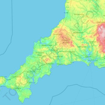
Name: Cornwall topographic map, elevation, terrain.
Location: Cornwall, England, United Kingdom (49.95541 -5.74711 50.93127 -4.16494)
Average elevation: 55 m
Minimum elevation: 0 m
Maximum elevation: 614 m
The interior of the county consists of a roughly east–west spine of infertile and exposed upland, with a series of granite intrusions, such as Bodmin Moor, which contains the highest land within Cornwall. From east to west, and with approximately descending altitude, these are Bodmin Moor, Hensbarrow north of St Austell, Carnmenellis to the south of Camborne, and the Penwith or Land's End peninsula. These intrusions are the central part of the granite outcrops that form the exposed parts of the Cornubian batholith of south-west Britain, which also includes Dartmoor to the east in Devon and the Isles of Scilly to the west, the latter now being partially submerged.
Other topographic maps
Click on a map to view its topography, its elevation and its terrain.
City of London
United Kingdom > England > City of London > City of London
City of London, England, EC2V 5AE, United Kingdom
Average elevation: 42 m
Stonehenge
United Kingdom > England > Larkhill
Stonehenge, The Avenue, Amesbury, Larkhill, Wiltshire, South West England, England, SP3 4DX, United Kingdom
Average elevation: 99 m
Water
United Kingdom > England > Devon > Teignbridge
Water, Teignbridge, Devon, England, TQ13 9UE, United Kingdom
Average elevation: 261 m
London
London, Greater London, England, United Kingdom
Average elevation: 66 m
Olveston
United Kingdom > England > South Gloucestershire
Olveston, South Gloucestershire, West of England, England, United Kingdom
Average elevation: 31 m
Goring-on-Thames
United Kingdom > England > Oxfordshire > South Oxfordshire
Goring-on-Thames, South Oxfordshire, Oxfordshire, England, RG8 0EB, United Kingdom
Average elevation: 84 m
Rotherham
Rotherham, South Yorkshire Mayoral Combined Authority, England, United Kingdom
Average elevation: 101 m
White Cliffs of Dover
United Kingdom > England > Kent > Dover > St. Margaret's at Cliffe
White Cliffs of Dover, St. Margaret's at Cliffe, Dover, Kent, England, United Kingdom
Average elevation: 49 m
Sunderland
Sunderland, North East, England, United Kingdom
Average elevation: 46 m
Northampton
United Kingdom > England > West Northamptonshire > Northampton
Northampton, West Northamptonshire, England, United Kingdom
Average elevation: 89 m
Shrewsbury
United Kingdom > England > Shrewsbury
Shrewsbury, Shropshire, West Midlands, England, SY1 1SF, United Kingdom
Average elevation: 71 m
Elveden
United Kingdom > England > Suffolk > West Suffolk
Elveden, West Suffolk, Suffolk, England, United Kingdom
Average elevation: 43 m
Fenny Bentley CP
United Kingdom > England > Derbyshire > Derbyshire Dales
Fenny Bentley CP, Derbyshire Dales, Derbyshire, England, United Kingdom
Average elevation: 193 m
Alfreton Park
United Kingdom > England > Derbyshire > Amber Valley > Alfreton CP > Oakerthorpe
Alfreton Park, Alfreton CP, Oakerthorpe, Amber Valley, Derbyshire, England, DE55 7AL, United Kingdom
Average elevation: 116 m
Dalbury
United Kingdom > England > Derbyshire > South Derbyshire
Dalbury, Dalbury Lees CP, South Derbyshire, Derbyshire, England, DE6 5BR, United Kingdom
Average elevation: 76 m
Cusworth
United Kingdom > England > Doncaster
Cusworth, Doncaster, South Yorkshire, England, DN5 8UZ, United Kingdom
Average elevation: 25 m
Kingsley Holt
United Kingdom > England > Staffordshire > Staffordshire Moorlands
Kingsley Holt, Staffordshire Moorlands, Staffordshire, England, ST10 2BG, United Kingdom
Average elevation: 184 m
Royal Leamington Spa
United Kingdom > England > Royal Leamington Spa
Royal Leamington Spa, Warwickshire, West Midlands, England, CV32 4DB, United Kingdom
Average elevation: 68 m
Welford
United Kingdom > England > West Berkshire
Welford, West Berkshire, England, United Kingdom
Average elevation: 124 m
Hazelwood CP
United Kingdom > England > Derbyshire > Amber Valley
Hazelwood CP, Amber Valley, Derbyshire, England, United Kingdom
Average elevation: 110 m
Alvescot
United Kingdom > England > Oxfordshire > West Oxfordshire
Alvescot, West Oxfordshire, Oxfordshire, England, United Kingdom
Average elevation: 87 m
Derbyshire Dales
United Kingdom > England > Derbyshire
Derbyshire Dales, Derbyshire, England, United Kingdom
Average elevation: 198 m
Hadfield
United Kingdom > England > Derbyshire > High Peak
Hadfield, High Peak, Derbyshire, England, United Kingdom
Average elevation: 174 m
Lew
United Kingdom > England > Oxfordshire > West Oxfordshire
Lew, West Oxfordshire, Oxfordshire, England, United Kingdom
Average elevation: 79 m
Great Shefford
United Kingdom > England > West Berkshire
Great Shefford, West Berkshire, England, United Kingdom
Average elevation: 148 m
River Glen
United Kingdom > England > Northumberland > Kirknewton
River Glen, Kirknewton, Northumberland, North of Tyne, England, United Kingdom
Average elevation: 97 m
Evershot
United Kingdom > England > Dorset
Evershot, Dorset, England, United Kingdom
Average elevation: 156 m
Wool
United Kingdom > England > Dorset > Bovington
Wool, Bovington, Dorset, England, United Kingdom
Average elevation: 37 m
Milburn
United Kingdom > England > Westmorland and Furness
Milburn, Westmorland and Furness, England, United Kingdom
Average elevation: 320 m
Brook
United Kingdom > England > Hampshire > New Forest > Bramshaw
Brook, Bramshaw, New Forest, Hampshire, England, SO43 7HE, United Kingdom
Average elevation: 65 m
West Tytherley
United Kingdom > England > Hampshire > Test Valley
West Tytherley, Test Valley, Hampshire, England, United Kingdom
Average elevation: 73 m
Selattyn
United Kingdom > England > Shropshire
Selattyn, Shropshire, England, SY10 7EZ, United Kingdom
Average elevation: 242 m
Cambourne
United Kingdom > England > Cambridgeshire > South Cambridgeshire
Cambourne, South Cambridgeshire, Cambridgeshire, Cambridgeshire and Peterborough, England, United Kingdom
Average elevation: 63 m
Goblin Ledge
United Kingdom > England > South Gloucestershire > Severn Beach > New Passage
Goblin Ledge, Prince of Wales Bridge, New Passage, Pilning and Severn Beach, Severn Beach, South Gloucestershire, West of England, England, BS35 4NQ, United Kingdom
Average elevation: 2 m
Heamoor
United Kingdom > England > Cornwall > Penzance
Heamoor, Penzance, Cornwall, England, TR18 3GD, United Kingdom
Average elevation: 70 m
Yorkshire Dales National Park
Yorkshire Dales National Park, England, United Kingdom
Average elevation: 298 m
Amport
United Kingdom > England > Hampshire > Test Valley
Amport, Test Valley, Hampshire, England, United Kingdom
Average elevation: 95 m
Crediton
United Kingdom > England > Devon > Mid Devon
Crediton, Mid Devon, Devon, England, United Kingdom
Average elevation: 71 m
Bramhall
Bramhall, Stockport, Greater Manchester, England, SK7 2JJ, United Kingdom
Average elevation: 82 m
White City
United Kingdom > England > Gloucestershire > Gloucester
White City, Gloucester, Gloucestershire, England, GL4 6UL, United Kingdom
Average elevation: 38 m
Buckover
United Kingdom > England > South Gloucestershire > Thornbury > Milbury Heath
Buckover, Milbury Heath, Thornbury, South Gloucestershire, West of England, England, GL12 8DX, United Kingdom
Average elevation: 65 m
Middleton Cheney
United Kingdom > England > West Northamptonshire
Middleton Cheney, West Northamptonshire, England, United Kingdom
Average elevation: 128 m
Muckleford
United Kingdom > England > Dorset > Grimstone
Muckleford, Bradford Peverell, Grimstone, Dorset, England, DT2 9SW, United Kingdom
Average elevation: 114 m
Pinewoods
United Kingdom > England > North Yorkshire > Harrogate
Pinewoods, Duchy, Harrogate, North Yorkshire, England, United Kingdom
Average elevation: 139 m
Willington Quay
United Kingdom > England > North Tyneside > Wallsend
Willington Quay, Howdon, Wallsend, North Tyneside, North of Tyne, England, NE28 6EA, United Kingdom
Average elevation: 23 m
Down Ampney
United Kingdom > England > Gloucestershire > Cotswold District
Down Ampney, Cotswold District, Gloucestershire, England, GL7 5QR, United Kingdom
Average elevation: 85 m
Derehams Park
United Kingdom > England > Buckinghamshire > Loudwater
Derehams Park, Rayners Avenue Mobile Home Park, Chepping Wycombe, Beaconsfield and Chepping Wye Community Board, Loudwater, Buckinghamshire, England, United Kingdom
Average elevation: 95 m
Red Lodge
United Kingdom > England > Suffolk > West Suffolk
Red Lodge, West Suffolk, Suffolk, England, United Kingdom
Average elevation: 22 m
Burn
United Kingdom > England > Norfolk > King's Lynn and West Norfolk > Burnham Overy
Burn, Burnham Overy, King's Lynn and West Norfolk, Norfolk, England, PE31 8DX, United Kingdom
Average elevation: 16 m