
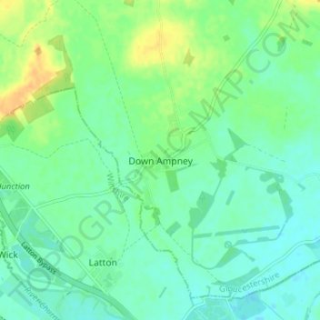
Down Ampney topographic map
Interactive map
Click on the map to display elevation.
About this map
Name: Down Ampney topographic map, elevation, terrain.
Average elevation: 85 m
Minimum elevation: 76 m
Maximum elevation: 103 m
Other topographic maps
Click on a map to view its topography, its elevation and its terrain.
Moreton-in-Marsh
United Kingdom > England > Gloucestershire > Cotswold District
Moreton-in-Marsh, Cotswold District, Gloucestershire, England, United Kingdom
Average elevation: 135 m
Lechlade
United Kingdom > England > Gloucestershire > Cotswold District
Lechlade, Cotswold District, Gloucestershire, England, GL7 3BY, United Kingdom
Average elevation: 81 m
Birdlip
United Kingdom > England > Gloucestershire > Cotswold District
Birdlip, Cotswold District, Gloucestershire, England, GL4 8BN, United Kingdom
Average elevation: 222 m
Broad Campden
United Kingdom > England > Gloucestershire > Cotswold District
Broad Campden, Cotswold District, Gloucestershire, England, GL55 6UU, United Kingdom
Average elevation: 167 m
Fairford
United Kingdom > England > Gloucestershire > Cotswold District > Fairford
Fairford, Cotswold District, Gloucestershire, England, United Kingdom
Average elevation: 98 m
Cirencester
United Kingdom > England > Gloucestershire > Cotswold District > Chesterton
Cirencester, Chesterton, Cotswold District, Gloucestershire, England, United Kingdom
Average elevation: 128 m