
Make a donation
Claveria topographic map
Click on the map to display elevation.
Make a donation
Claveria
The town has a generally rugged topography, characterized by gently rolling hills and mountains with cliffs and escarpments. The soil is classified as Jasaan clay, with a deep soil profile (greater than 1 m) and rapid drainage. It is generally acidic (pH 3.9 to 5.2), with low cation exchange capacity (CEC), low to moderate organic matter content (1.8%), high aluminium saturation, and low levels of available phosphorus and exchangeable potassium.
Make a donation
About this map
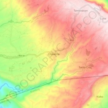
Name: Claveria topographic map, elevation, terrain.
Average elevation: 663 m
Minimum elevation: 255 m
Maximum elevation: 950 m
Make a donation
Other topographic maps
Click on a map to view its topography, its elevation and its terrain.
Make a donation
Make a donation
Cagayan de Oro River
Philippines > Misamis Oriental > Cagayan De Oro > Balulang
Average elevation: 98 m
Make a donation
Make a donation