
Chiriquí topographic map
Interactive map
Click on the map to display elevation.
About this map
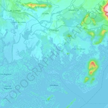
Name: Chiriquí topographic map, elevation, terrain.
Location: Chiriquí, Distrito David, Chiriquí, Panamá (8.26794 -82.39802 8.44175 -82.20538)
Average elevation: 22 m
Minimum elevation: -2 m
Maximum elevation: 405 m
Other topographic maps
Click on a map to view its topography, its elevation and its terrain.
Angostura de Cochea Arriba
Panamá > Chiriquí > Distrito David > Cochea
Angostura de Cochea Arriba, Cochea, Distrito David, Chiriquí, Panamá
Average elevation: 174 m
David Sur
Panamá > Chiriquí > Distrito David
David Sur, Distrito David, Chiriquí, Panamá
Average elevation: 20 m
David Este
Panamá > Chiriquí > Distrito David
David Este, Distrito David, Chiriquí, Panamá
Average elevation: 13 m
Quiteño
Panamá > Chiriquí > Distrito David > Las Lomas
Quiteño, Las Lomas, Distrito David, Chiriquí, Panamá
Average elevation: 91 m
Cochea
Panamá > Chiriquí > Distrito David
Cochea, Distrito David, Chiriquí, Panamá
Average elevation: 217 m
Pedregal
Panamá > Chiriquí > Distrito David > Pedregal
Pedregal, Distrito David, Chiriquí, Panamá
Average elevation: 4 m
David Este
Panamá > Chiriquí > Distrito David > David Este > David Este
David Este, Distrito David, Chiriquí, 7790414, Panamá
Average elevation: 34 m
Parque La Amistad
Panamá > Chiriquí > Distrito David > David
Parque La Amistad, Doleguita, David, Distrito David, Chiriquí, Panamá
Average elevation: 43 m
San Pablo Viejo
Panamá > Chiriquí > Distrito David
San Pablo Viejo, Distrito David, Chiriquí, Panamá
Average elevation: 79 m