
Pithoragarh topographic map
Interactive map
Click on the map to display elevation.
About this map
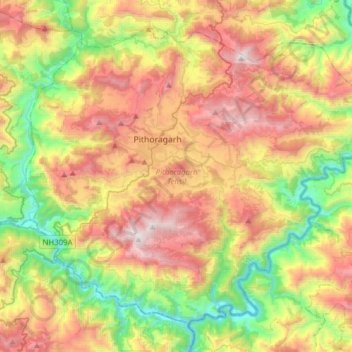
Name: Pithoragarh topographic map, elevation, terrain.
Location: Pithoragarh, Uttarakhand, India (29.44403 80.09943 29.67038 80.40881)
Average elevation: 1,316 m
Minimum elevation: 421 m
Maximum elevation: 2,454 m
Other topographic maps
Click on a map to view its topography, its elevation and its terrain.
Roorkee
India > Uttarakhand > Roorkee
Roorkee is located at 29°52′N 77°53′E / 29.87°N 77.88°E / 29.87; 77.88. It has an average elevation of 268 metres (879 ft).
Average elevation: 270 m