
Drumheller (town) topographic map
Interactive map
Click on the map to display elevation.
About this map
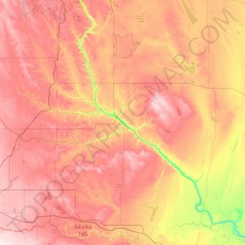
Name: Drumheller (town) topographic map, elevation, terrain.
Location: Drumheller (town), Alberta, T0J 2V0, Canadá (50.77693 -113.28024 52.05693 -112.00024)
Average elevation: 855 m
Minimum elevation: 637 m
Maximum elevation: 1,086 m
Other topographic maps
Click on a map to view its topography, its elevation and its terrain.
Edmonton
Canadá > Alberta > Division No. 11
Edmonton, Division No. 11, Alberta, Canadá
Average elevation: 690 m
Fort McKay
Canadá > Alberta > Wood Buffalo
Fort McKay, Wood Buffalo, Alberta, Canadá
Average elevation: 259 m
Canmore
Canadá > Alberta > Division No. 15
Canmore, Division No. 15, Alberta, T1W 2H4, Canadá
Average elevation: 1,565 m
Town of Cochrane
Canadá > Alberta > Town of Cochrane
Town of Cochrane, Alberta, Canadá
Average elevation: 1,200 m
Municipal District of Greenview
Canadá > Alberta > Municipal District of Greenview
Municipal District of Greenview, Alberta, Canadá
Average elevation: 927 m
Municipality of Jasper
Municipality of Jasper, Alberta, T0E 1E0, Canadá
Average elevation: 1,798 m
Kananaskis Improvement District
Kananaskis Improvement District, Alberta, Canadá
Average elevation: 1,740 m