
Make a donation
Agerola topographic map
Click on the map to display elevation.
Make a donation
About this map
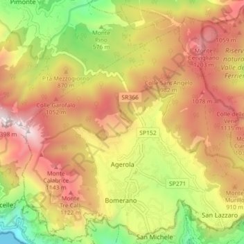
Name: Agerola topographic map, elevation, terrain.
Location: Agerola, Naples, Campania, 80051, Italy (40.62081 14.50938 40.67315 14.58049)
Average elevation: 743 m
Minimum elevation: 0 m
Maximum elevation: 1,400 m
Make a donation
Other topographic maps
Click on a map to view its topography, its elevation and its terrain.
Mount Vesuvius
Italy > Campania > Naples > Trecase
The volcano's slopes are scarred by lava flows, while the rest are heavily vegetated, with scrub and forests at higher altitudes and vineyards lower down.
Average elevation: 862 m
Mount Vesuvius
Italy > Campania > Naples > Trecase
The volcano's slopes are scarred by lava flows, while the rest are heavily vegetated, with scrub and forests at higher altitudes and vineyards lower down.
Average elevation: 862 m
Make a donation
Country Park
Italy > Campania > Naples > Giugliano in Campania > Amodio-Massariola
Average elevation: 50 m
Mount Vesuvius
Italy > Campania > Naples > Trecase
The volcano's slopes are scarred by lava flows, while the rest are heavily vegetated, with scrub and forests at higher altitudes and vineyards lower down.
Average elevation: 862 m
Make a donation
Monte Solaro
Italy > Campania > Naples > Anacapri
Monte Solaro is a mountain on the island of Capri in Campania, Italy. With an elevation of 589 m, its peak is the highest point of Capri.
Average elevation: 155 m
Mount Vesuvius
Italy > Campania > Naples > Trecase
The volcano's slopes are scarred by lava flows, while the rest are heavily vegetated, with scrub and forests at higher altitudes and vineyards lower down.
Average elevation: 862 m
Monte Faito
Italy > Campania > Naples > Vico Equense
The summit has an elevation of 1,131 metres (3,711 ft).
Average elevation: 831 m
Make a donation
Make a donation
Mount Vesuvius
Italy > Campania > Naples > Trecase
The volcano's slopes are scarred by lava flows, while the rest are heavily vegetated, with scrub and forests at higher altitudes and vineyards lower down.
Average elevation: 862 m
Mount Vesuvius
Italy > Campania > Naples > Trecase
The volcano's slopes are scarred by lava flows, while the rest are heavily vegetated, with scrub and forests at higher altitudes and vineyards lower down.
Average elevation: 862 m
Make a donation
Mount Vesuvius
Italy > Campania > Naples > Trecase
The volcano's slopes are scarred by lava flows, while the rest are heavily vegetated, with scrub and forests at higher altitudes and vineyards lower down.
Average elevation: 862 m
Make a donation