
Rolle topographic map
Interactive map
Click on the map to display elevation.
About this map
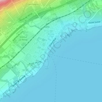
Name: Rolle topographic map, elevation, terrain.
Location: Rolle, District de Nyon, Waadland, 1180, Zwitserland (46.44348 6.31832 46.46788 6.35183)
Average elevation: 394 m
Minimum elevation: 370 m
Maximum elevation: 537 m
Other topographic maps
Click on a map to view its topography, its elevation and its terrain.
Longirod
Zwitserland > Waadland > District de Nyon > Longirod
Longirod, District de Nyon, Waadland, 1261, Zwitserland
Average elevation: 985 m
La Dôle
Zwitserland > Waadland > District de Nyon > Gingins
La Dôle, Gingins, Grand Genève, District de Nyon, Waadland, 1276, Zwitserland
Average elevation: 1,435 m
Genolier
Zwitserland > Waadland > District de Nyon
Genolier, District de Nyon, Waadland, 1272, Zwitserland
Average elevation: 564 m
Gilly
Zwitserland > Waadland > District de Nyon
Gilly, District de Nyon, Waadland, 1182, Zwitserland
Average elevation: 604 m
Gingins
Zwitserland > Waadland > District de Nyon
Gingins, District de Nyon, Waadland, 1276, Zwitserland
Average elevation: 773 m
Nyon
Zwitserland > Waadland > District de Nyon
Nyon, District de Nyon, Waadland, 1260, Zwitserland
Average elevation: 404 m