Geolocate

Piedmont Lake topographic map

Click on the map to display elevation.

About this map

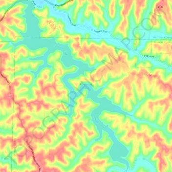
Name: Piedmont Lake topographic map, elevation, terrain.

Location: Piedmont Lake, Belmont County, Ohio, United States (40.10029 -81.22856 40.19215 -81.14352)

Average elevation: 321 m

Minimum elevation: 266 m

Maximum elevation: 392 m

Other topographic maps

Click on a map to view its topography, its elevation and its terrain.

Wolfhurst

United States > Ohio > Belmont County

Average elevation: 296 m

Warnock

United States > Ohio > Belmont County

Average elevation: 337 m

Captina

United States > Ohio > Belmont County

Average elevation: 289 m

Boston

United States > Ohio > Belmont County

Average elevation: 366 m

Barton

United States > Ohio > Belmont County

Average elevation: 315 m

Badgertown

United States > Ohio > Belmont County

Average elevation: 366 m

Centerville

United States > Ohio > Belmont County

Average elevation: 362 m

Alledonia

United States > Ohio > Belmont County

Average elevation: 320 m

Neffs

United States > Ohio > Belmont County > Neffs

Average elevation: 300 m

Lloydsville

United States > Ohio > Belmont County

Average elevation: 360 m

Lansing

United States > Ohio > Belmont County

Average elevation: 297 m

Lafferty

United States > Ohio > Belmont County

Average elevation: 344 m

Morristown

United States > Ohio > Belmont County

Average elevation: 374 m

Bannock

United States > Ohio > Belmont County

Average elevation: 339 m

Blaine

United States > Ohio > Belmont County

Average elevation: 310 m

Glencoe

United States > Ohio > Belmont County

Average elevation: 317 m

Flushing

United States > Ohio > Belmont County

Average elevation: 365 m

Holloway

United States > Ohio > Belmont County

Average elevation: 313 m

Brookside

United States > Ohio > Belmont County

Average elevation: 281 m

Bridgeport

United States > Ohio > Belmont County

Average elevation: 244 m

Bethesda

United States > Ohio > Belmont County

Average elevation: 376 m

Belmont

United States > Ohio > Belmont County

Average elevation: 361 m

Crescent

United States > Ohio > Belmont County

Average elevation: 314 m

Martins Ferry

United States > Ohio > Belmont County

Average elevation: 288 m

Yorkville

United States > Ohio > Belmont County

Average elevation: 256 m

Powhatan Point

United States > Ohio > Belmont County

Average elevation: 241 m

Shadyside

United States > Ohio > Belmont County

Average elevation: 245 m

Jacobsburg

United States > Ohio > Belmont County

Average elevation: 356 m