
Thank you for supporting this site ❤️
Make a donation
Make a donation
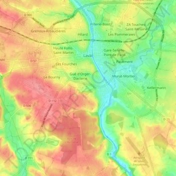
Laval topographic map
Click on the map to display elevation.
Thank you for supporting this site ❤️
Make a donation
Make a donation
Laval
Elevation varies between 42 and 122 meters above sea level. Laval is, in fact, a hilly town, marked by a rocky promontory dominating the valley of the Mayenne river. The castle was built on this promontory and the medieval centre spreads around. The promontory and the slightly hilly landscape around Laval are traces of the Armorican Massif, an old range of mountains that forms the Breton peninsula.
Thank you for supporting this site ❤️
Make a donation
Make a donation
About this map
Name: Laval topographic map, elevation, terrain.
Average elevation: 87 m
Minimum elevation: 42 m
Maximum elevation: 128 m
Thank you for supporting this site ❤️
Make a donation
Make a donation