
Make a donation
Freshford topographic map
Click on the map to display elevation.
Make a donation
About this map
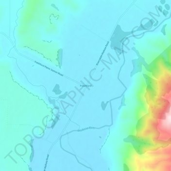
Name: Freshford topographic map, elevation, terrain.
Location: Freshford, Southland District, Southland, New Zealand (-45.79087 168.77386 -45.75087 168.81386)
Average elevation: 191 m
Minimum elevation: 138 m
Maximum elevation: 525 m
Make a donation
Other topographic maps
Click on a map to view its topography, its elevation and its terrain.
Hikuraki / North Mavora Lake
New Zealand > Southland > Southland District > Fiordland Community
Average elevation: 1,071 m
Lake Te Anau
New Zealand > Southland > Southland District
Lake Te Anau (Māori: Te Ana-au) is in the southwestern corner of the South Island of New Zealand. The lake covers an area of 344 km2 (133 sq mi), making it the second-largest lake by surface area in New Zealand (after Lake Taupō) and the largest in the South Island. It is the second largest lake in…
Average elevation: 684 m
Make a donation
Long Beach
New Zealand > Southland > Southland District > Waihopai Toetoe Community
Average elevation: 36 m
Little River
New Zealand > Southland > Southland District > Stewart Island/Rakiura Community
Average elevation: 62 m